Home »

Region weathers second day of flooding
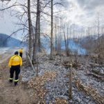
Today (June 21), e-KNOW toured the Elk Valley, photographing the flooding and damages and recording this momentous point in our time. Please see our photo gallery below.
Many hundreds of exhausted East Kootenay residents hit the hay this evening – spent from a day of back-draining labour.
Neighbour has been pitching in for neighbor, and neighbouring community has been helping their neighbours sandbag and race to erect temporary dikes and divert channels as the water levels of the Elk, Kootenay and Columbia Rivers and their key tributaries have surged well beyond normal spring/early summer freshet levels.
Hosmer, east of Fernie, is the hardest hit community, thus far, with 33 residents having been evacuated – part of five Local States of Emergency declared in the past 48 hours in the region (Elkford, Sparwood, Fernie, Electoral Area A and Fairmont/Dutch Creek).
Volunteer sandbaggers and emergency personnel spent the day in the small community racing to help friends and neighbours.
Kootenay East MLA and Minister of Mines Bill Bennett and constituency assistant Jennifer Osmar arrived at the Hosmer Community Hall/Fire Department this afternoon (June 21) as part of a tour of the Elk Valley. While e-KNOW was photographing people sandbagging, Bennett informed us that “all those people sandbagging are volunteers and aren’t the homeowners.”
The homeowners are waging an ongoing battle to stem the relentless spread of the Elk River from the normal melt and an abnormal volume of rain, and volunteers are delivering sandbags to them. There was a military precision to the efforts at Hosmer with a ‘get ‘er done’ determination that did all the volunteers proud.
The line of half and three-quarter ton trucks trucks waiting to be filled with sandbags at the Hosmer Hall numbered close to 20 at times.
The hardest hit properties are along the north side of Highway 3 and Hosmer.
In Sparwood, it appears as though the CPR tracks and rail bed have served to spare some properties, though creek-side work was evident throughout the day. There has also been some damage to railway tracks leading to the mines.
The Highway 43 entry to Elkford (to Fording Junction) was closed for most of the day but the road re-opened in the late afternoon. The explosive power of the flow of water at the point where Boivin Creek enters the Elk River is deafening.
The business section across from the golf course has experienced some flooding and three or four properties north of Elkford, on the Elk Lakes Provincial Park Road, are completely flooded.
The City of Fernie declared a State of Local Emergency earlier in the day, as the Elk has its way through the woods of James White Park, closed due to dangerous water levels.
Annex residents, and many other Fernie residents, are battling the surge of ground water, while about six properties on Cokato Road are flooding. City of Fernie Mayor Mary Giuliano has issued a plea on Facebook for volunteers to head out to Cokato Road and help residents there.
West Fernie residents may be uttering some thanks to the provincial, federal and regional powers that be for finding the bucks to beef up the dike. A few properties are experiencing some flooding but the bulk of the community remains dry – on the surface at least. Many homes are pumping water from basements and crawl spaces today – throughout the region as water tables are maxed.
In Kimberley, Morrison Subdivision residents are breathing through gritted teeth this evening. For the second June in a row, they are dealing with Kimberley Creek once again bursting her banks.
Late this evening, a new report emerged of water starting to lap onto Highway 93/95 by Wasa – so drivers are urged to take care.
The Village of Canal Flats is keeping a close eye on the Kootenay River and Columbia Lake, with Mayor Ute Juras using Facebook to try and keep residents updated.
North in Fairmont Hot Springs, the watch continues on the angry and roiling Dutch Creek, which has flooded a portion of Hoodoos Resort Campground.
Officials are keeping an eye on the Dutch Creek Hoodoos Bridge on Highway 93/95 but it remains open.
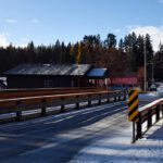
However, the news of the day for the valley was the closure of the Springbrook Bridge at Skookumchuck, severing passage on the north/south Highway 93/95.
A hunk of the southbound lane on the west side of the river was blown away by the river, forcing the road closure. Earlier this evening, Ministry of Transportation and Infrastructure officials deemed the bridge passable and traffic is moving alternately single-lane.
With Highway 93 (Kootenay National Park) closed due to washouts and the Trans-Canada closed at Canmore, the valley was cut off from its Alberta-fed tourism industry lifeblood when the bridge was closed.
E-KNOW has heard reports that store shelves have been cleaned out of some supplies, such as drinking water, and a gasoline shortage has occurred in Invermere.
Creek and riverbanks have taken a major beating in the past 48 to 72 hours and can be unstable. You don’t don’t want to end up in the drink at this time – as that swirling, ice cold chocolate milk is lousy with trees and lethal snags. You wouldn’t stand a chance if you ended up in the water.
There is an impressive volume of debris in the waterways. The Kootenay and Elk are pushing along huge volumes of forest matter – with cottonwoods going down on a steady basis.
Earlier this evening Premier Christy Clark issued the following statement regarding flooding in the area: “British Columbians have been following the footage of the devastating impacts of the flooding here at home and in Alberta.
“While the Mission Creek flow rate has dropped, the Southeast is still facing evacuation alerts. Emergency officials and Minister Bill Bennett are monitoring the situation in Elkford, Hosmer and Sparwood closely to ensure residents have the resources they need.
“Like all Canadians, I have been struck by the images and video from Southern Alberta. My thoughts and prayers are with all those affected.
“I urge all British Columbians who live in areas vulnerable to flooding to be prepared and have a plan.”
Several emergency workers today asked e-KNOW to be safe and give emergency workers and volunteers the space they need to do their thing. And don’t put yourself and others at risk.
Lead image: Kootenay East MLA Bill Bennett speaks with Hosmer residents this afternoon, June 21, while conducting a tour of the Elk Valley to get a sense of the scale of the flooding.
Click on an image to enlarge and to begin the self-directed slide show (click button at bottom right to advance to next photo).


Ian Cobb/e-KNOW
Images by
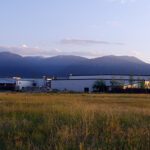
Train tracks that lead two 3 major coal mines, line creek operations, green hills operations and fording river operations. By Pamela Hildebrandt
Marysville Falls roaring, Closed Mark Creek Bridge, Closed Skookumchuck Bridge, Highway 93-95 near Wasa, CP Rail line almost covered by Kootenay River near Wasa images by Gerry Warner
Images of Morrison Subdivision in Kimberley by Chris Newel
All the remaining images by Carrie Schafer/Through My Eyes Photography and Ian Cobb/e-KNOW