Home »

Survey asks Canal Flats residents about proposed park

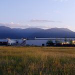
The Village of Canal Flats is interested in establishing a park along the northern bank of the Kootenay River.
The area of the proposed park stretches from approximately 200 metres southwest of the Highway 95 Bridge along the Kootenay River to the edge of the bridge. The proposed park area is approximately 1.2 hectares in size.
The creation of this park is supported through the Canal Flats Parks, Recreation and Trails Strategy, which was completed in 2020.
To help in guidance, the village is asking residents to complete a two-minute survey.
The survey will be open until May 26.
Personal information collected regarding residency and age will not be stored or shared with any third party.
Lead image: A family walks along the Kootenay River in the area proposed for a village park. e-KNOW file photo
e-KNOW