Home »

Area restrictions in effect due to wildfires
The BC Wildfire Service has implemented two Area Restriction Orders for the vicinity of the Tanglefoot Creek wildfire (N11958), northeast of Cranbrook, and Ptarmigan Creek wildfire (N21981) near Whiteswan Lake Provincial Park.
These area restrictions reflect the continued need to protect the public in areas where ongoing fire suppression activities are taking place.
These orders are currently in effect, each order will remain in effect until 12:00 noon (PDT) on September 15, or until it is rescinded.
The orders apply to Crown land within the geographic boundaries described below and outlined in the correlated maps:

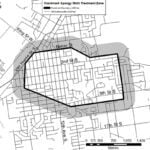
Tanglefoot Creek wildfire (N11958), originated 30 kilometres northeast of Cranbrook:
- Commencing at the junction of the Galbraith FSR and Tanglefoot Creek FSR, north following the Galbraith Creek FSR, then north and east to the height of land to Duncan Creek, then west along the height of land to Mt Smith.
- Then following the height of land to the south through Mt Fisher, back to east until the junction of the Bull Van FSR and Bull River Main FSR, then north to the commencement point.
- Note: travel along the Bull River Main FSR, Bull Van FSR and Galbraith FSR is permitted.
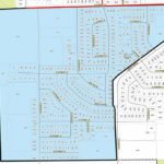
 Ptarmigan Creek wildfire (N21981), originated 23 kilometres northeast of Canal Flats:
- Commencing at the junction of Moscow FSR and the northeast corner of Whiteswan Provincial Park, west along Whiteswan Provincial Park northern boundary, then north up to White Knight Peak, continuing north along the height of land to Edwards Peak, east long Edwards FSR to the commencement point at Moscow FSR.
- Note: access to Whiteswan Provincial Park and travel on the Moscow FSR is permitted. Travel along Edwards FSR is prohibited.
Under this Order and section 11(2) of the Wildfire Act, a person must not remain in or enter the restricted area without the prior written authorization of an official designated for the purposes of the Wildfire Act, unless the person:
1.) first receives written authorization of an official designated for the purposes of the Wildfire Act, or
2.) Enters the area only in the course of:
(a) travelling to or from his or her principle residence that is not under an evacuation order;
(b) using a highway as defined in the Highway Act;
(c) travelling as a person acting in an official capacity as defined in s.56 of the Wildfire Act; or
(d) travelling for the purpose of supporting wildfire suppression or enforcement patrol activities.
This Order is subject to and subordinate to any applicable evacuation orders made under the Emergency Program Act.
Failure to comply with Section 11 restricted area requirements may result in a violation ticket of $1,150.
Road closures and area restrictions are subject to change depending on fire activity. For the most current information please visit the bans and restrictions section of the BC Wildfire website for the Southeast Fire Centre.
The Southeast Fire Centre extends from the U.S. border in the south to Mica Dam in the north, and from the Okanagan Highlands and Monashee Mountains in the west, to the B.C.-Alberta border in the east.
To report a wildfire, unattended campfire or open burning violation, call 1 800 663-5555 toll- free or *5555 on a cellphone.
For the latest information on current wildfire activity, burning restrictions, road closures and air quality advisories, go to: www.bcwildfire.ca or download the BC Wildfire Service public mobile app.
Regional wildfire update to follow in e-KNOW.
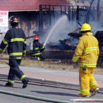
Lead image: A smoke plume billows up behind Fisher Peak from the Tanglefoot wildfire. Ian Cobb/e-KNOW photo
e-KNOW