Home »

BCWS beefs Bill Nye crew to finalize containment lines
Brief assistance from Mother Nature July 21 appears to have helped slow the Bill Nye Mountain wildfire, seven km southeast of Wasa.
BC Wildfire Service (BCWS) today (July 22) reports the Bill Nye Mountain wildfire has grown 1,107 hectares in size – up 50 ha from yesterday.
“The small amount of rain from yesterday cooled the fire temporarily. Fire behaviour on this incident continues to be a smouldering to low vigour surface fire; with occasional flare-ups are pockets of unburnt fuels found on the north and south flank at higher elevations,” BCWS stated in its fire of note report.
 “Strong winds are expected to continue today and keep driving aggressive fire behaviour in the interior, southern interior, and southeast region of the province. These winds will begin to diminish over the coming days.”
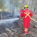
Additional crews are being brought in today to help heavy machinery finalize the containment lines at the base of the mountain, creating a hand-built fuel-free on the north and west perimeter, BCWS reported
“The established sprinkler system on the control lines has been turned on and helping to keep the area humid. Additional crews will also be working on prepping the space for direct suppression action. Helicopters remain available to bucket the fire on an as needed basis and to move crews around.”
There are 23 firefighters battling the fire today, along with a helicopter and two pieces of heavy machinery.
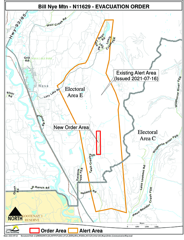
On July 21, the Regional District of East Kootenay (RDEK) implemented an evacuation order for two properties in the Lakit Creek FSR area of Electoral Area E.
The RDEK has an evacuation alert is in place for 54 properties in the Lazy Lake, Lakit Lake, Holmes Road, and Wildhorse FSR areas.
The lightning-caused Tanglefoot Creek wildfire, discovered July 16 about 15 km southeast of the Bill Nye fire, remains out-of-control at 325 ha.
The lightning-caused fire near Big Lake south of Wasa, discovered July 13, is today reported as under control at 11 ha.
BCWS reports only one new wildfire in the East Kootenay area overnight.
Lightning ignited an estimated 1.1 ha fire along Marian Lake Forest Service Road, eight km northeast of Castledale on the east side of Castle Mountain.
Two other wildfires in the East Kootenay remain out-of-control today.
The lightning-caused fire discovered July 16 in Dewar Creek about 2.5 km west of Price Lake in St. Mary Alpine Provincial Park, about 36 km northwest of Kimberley, remains out-of-control at 58 ha.
And the lightning-caused Ptarmigan Creek wildfire five km north of Whiteswan Lake Provincial Park remains out-of-control at 55 ha.
Two other regional fires are being held today, including Granite Creek in the Purcell Wilderness Conservancy, at 26 ha and the lightning-caused fire in Forsite, discovered July 19 on a slope on the east side of White River, 28 km northeast of Canal Flats at an estimated .6 ha.
The Moyie River and Bear Creek fires remain under control.
Lead image: A sign that should go without saying at this time, just off Lazy Lake Road east of Wasa. The Bill Nye Wildfire burns in the background. Ian Cobb/e-KNOW photo
e-KNOW