Home »

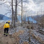
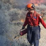
Fire Centre keeping abreast of wildfires in region
Two new wildfires are being reported in the East Kootenay by BC Wildfire Service today (July 12).
One is located in Britt Creek, on the east side of the Elk River, about 23 km north of Elkford. The fire today is an estimated .01 hectare. Its cause is unknown at this time.
Another new fire located today is on a ridge west of the Lussier River and Highway 93/95, about 12 km southwest of Canal Flats. Also of unknown cause, that fire is .01 ha.
Two fires reported as new near Canal Flats yesterday are now under control and being held.
The lightning-caused fire near Centaur Lake, about five km south of Canal Flats, located between Findlay Creek and the Kootenay River is under control. The fire is estimated at three hectares.
A second fire is about 11 km northeast of the first, alongside North Lussier River Road, about nine km southeast of Canal Flats is being held. Discovered July 11, the cause of the estimated .04 ha fire is unknown at this time.
The Bill Nye Mountain wildfire, about eight km southeast of Wasa, remains out of control at about .6 hectares in size. Discovered July 8, the suspected cause of the fire is lighting.
All other fires (eight) in the East Kootenay are considered under control.
Close to the region, there is another new lightning-caused fire 11 km west of Donald on Blackwater Ridge. The fire is an estimated 40 ha.
The Carroll Creek fire, about 25 km west of Donald, on the west side of Kinbasket Lake, remains out of control at 98 ha.
The fire discovered July 10 about 24 km north of Kitchener at Kamma Creek is out of control at 15 ha in scale.
Another new fire was discovered today nearby on the west side of the Goat River drainage. It is an estimated .01 ha.
A lightning-caused fire discovered July 11 at Corney Creek, about 20 km northeast of Johnson’s Landing, is out of control at five ha.
There is an out-of-control wildfire six km east of Boswell at Akokli Creek. Lightning-caused July 9, the fire is an estimated 95 ha.
Nine km northeast of that fire is another lightning-caused blaze discovered July 11 in Redding Creek that is already 100 ha.
Across Kootenay Lake, the Cultus Creek, discovered July 2, is still out of control at 46 ha.
Check out the BC Wildfire Service Wildfire Dashboard for up-to-date information on wildfires.
Lead image: BC Wildfire Service map for today shows the fire risk in the East Kootenay as mostly high with growing sections of extreme taking over.
e-KNOW