Home »
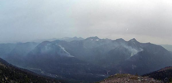
Meachen Creek fire remains in drainage
 BC Wildfire Service (BCWS) reported last night the Meachen Creek wildfire has not spread into the St. Mary Valley.
“Active winds gusting up to 40 km/h increased fire activity late on August 16. However, fire activity settled down late the same evening. The fire has not entered the (St. Mary) valley; it has remained in the Meachen drainage,” BCWS said.
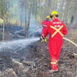
Crews constructed guards yesterday with the aid of heavy equipment and air support. The area is being assessed for potential burn off operations to increase containment.
Discovered August 1, the now 5,685 ha fire is in Kianuko Provincial Park and Meachen Creek drainage, approx. 10 km southwest of St. Mary Lake.
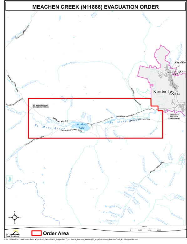
An evacuation order has been issued by the Regional District of East Kootenay (RDEK) in the St. Mary Lake area from the west boundary of the City of Kimberley to the Redding Creek/St. Mary River convergence including St. Mary Lake Road and Lakefront Road.
 An evacuation alert has been issued by the Regional District of East Kootenay for the entire City of Kimberley Municipal Boundary, and properties in the RDEK directly south and southeast of the City of Kimberley Municipal Boundar
For more information on this alert, please call the RDEK at 250 426-2188 or visit their website.
Expanded forest service road restrictions are in effect for the Meachen Creek, Redding Creek, Grey Creek and White Boar forest service roads.
Beginning at the 31 km mark of St. Mary Lake Road, the Redding Creek forest service road is closed to the height of land, and the 25.3 km mark on the Hellroaring forest service road junction with the St. Mary River Main forest service road.
BC Parks has also issued a partial closure of Kianuko Provincial Park.
BC Wildfire Service personnel are working together with the Regional District of East Kootenay, Teck Cominco and the City of Kimberley on this fire.
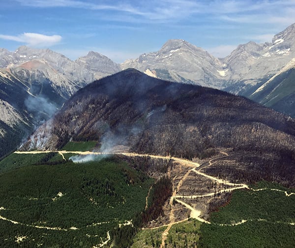
The three-fire Lost Dog Complex wildfire, approximately 14 kilometres north of Kimberley is now an estimated 706 ha.
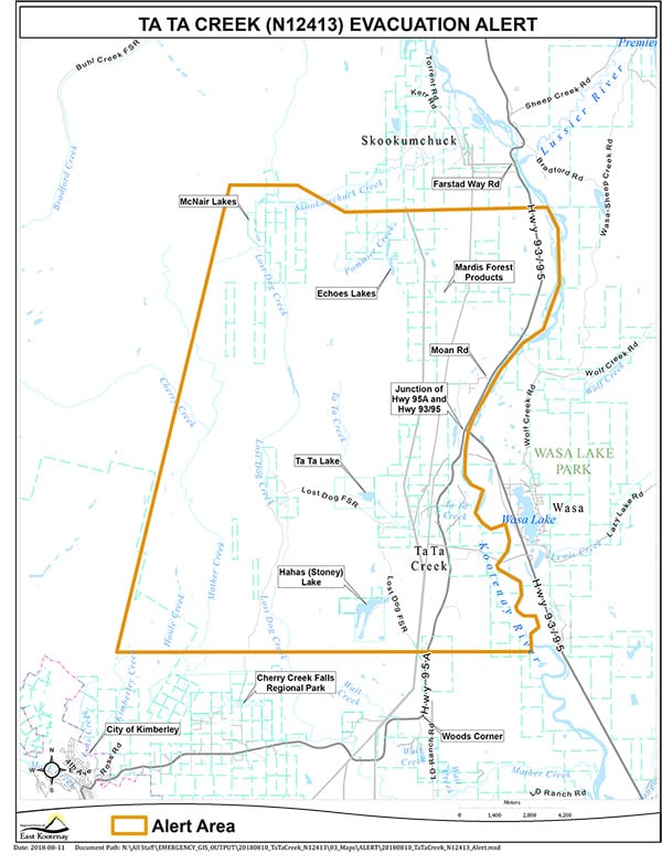
An evacuation alert has been issued by the Regional District of East Kootenay in the Ta Ta Creek area including west of the Kootenay River from 1.5 km south of Farstad Way Road to 2.5 km north of Woods Corner.
Ignition operations on the Lost Dog Complex were a success on August 15. Crews successfully reinforced control lines on critical flanks.
The smaller two fires in the complex are now “being held” and ground crews are onsite mopping up.
Yesterday there were 45 firefighters, three helicopters and four pieces of heavy equipment on the fire. Ground crews, aviation and heavy equipment are working to contain this fire, BCWS reported.
Update on other fires of note as per BCWS
Coal Creek
Approximately 12 kilometres east of Fernie, this fire is now 713 ha after being discovered August 10.
This wildfire is highly visible from Fernie and Alberta. This fire is not currently threatening communities, BCWS reported.
The Coal Creek Forest Service Road is closed beginning at the 33 km mark. The Leach Creek Forest Service Road is restricted beginning at the junction of Leach Creek Forest Service Road. The Corbin Road, and Morrissey Creek Forest Service Road are restricted beginning at the 0.3 km on Morrissey Forest Service Road, from the junction with Morrissey Road.
The cause of this fire is currently unknown and is under investigation.
Yesterday had nine firefighters, heavy equipment and air support worked on containment.
Sage Creek
 Approximately 65 km south east of Fernie and approximately six km south west of the B.C.-AB border, this fire is now an estimated 1,947 ha.
This fire is burning in remote terrain. Crews are working to reinforce the Flathead Sage Forest Service Road as a guard on the north end of the fire. The south side of the fire is burning upslope and connecting with the fuel break created from the Kenow Mountain wildfire from 2017.
“This fire is a modified response fire meaning it is managed using a combination of suppression techniques, including direct and indirect attack, and monitoring to steer, contain and otherwise manage fire activity within pre-determined perimeters. This type of response is used to minimizes costs and/or damage and to maximize benefits from the fire,” BCWS outlined.
There was minimal growth during the day. Crews and equipment made good progress along the perimeter. Bucketing and airtanker drops continued in priority areas. Crews will continue to work the line with pump and hose supported by helicopter bucketing; aerial suppression will continue to limit further spread along the perimeter. Ignition sites to be identified in the north.
Yesterday there were 109 firefighters, 10 helicopters and two airtankers on the fire.
The Flathead Sage Creek Forest Service Road is closed starting at the 81-kilometre mark at the junction of Flathead Kishinena Forest Service Road and the Flathead Sage Forest Service Road. No access is permitted on this section of road. This road will remain closed until the public is otherwise notified.
Leach Creek
Approximately three km north of Mount Taylor and 21 km southeast of Sparwood, this fire is ‘being held’ meaning that sufficient suppression action has been taken that the fire is not likely to spread beyond existing or predetermined boundaries under the prevailing and forecasted conditions.
The 30 ha fire is 95% guarded and the evacuation alert for Corbin has been rescinded for residents affected by this fire.
Crews are working to strengthen guards today. Good progress has been made with no spread of the fire overnight.
Cross River
Discovered Wednesday, August 1, this fire, which has triggered an evacuation order for 10 properties, including Nipika Mountain Resort, is now 2,921.0 hectares (estimated) in scale.
The fire is approximately nine km east of Highway 93 in Kootenay National Park, and about 23 km northeast of the Village of Radium Hot Springs.
For more information on this evacuation order, please call the RDEK at 250 426-2188 or visit their website at: www.rdek.bc.ca.
This fire is a modified response fire meaning it is managed using a combination of suppression techniques, including direct and indirect attack, and monitoring to steer, contain and otherwise manage fire activity within pre-determined perimeters.
Cross River FSR restriction beginning at the 10 km mark of Settler’s Road, continuing down the Ravenheads FSR to the 44.75 km mark and continuing north on the Cross River FSR to the Cross Mitchell FSR junction. The Palliser FSR is restricted from the junction of the Kootenay River/Palliser FSR at the 40.25 km mark, continuing up Palliser FSR to the area around Nipika lodge.
Randal Creek
About 17 km southeast of Yahk on the B.C./U.S.A. border, this fire has grown to 879 ha.
Discovered Saturday, August 11, this fire has triggered an Evacuation Alert for one property for in the Yahk area.
An area restriction is in effect for the area past the 6 km mark on the Yahk Meadow Creek Road.
The lightning-caused fire had 23 firefighters, two helicopters and five pieces of heavy equipment on it yesterday (August 17).
Crews continue to work on containment lines on the east flank with the aid of air support.
Crews continue to assess for potential burn off operations to be implemented when appropriate.
Bloom/Wickman
Located about 18 km west of Newgate, this fire is now listed as being 577 ha. BCWS does not provide any other information, aside from it being lightning-caused and discovered on August 11.
Whitetail Creek
Located about 17 km east of Spillimacheen, this is the longest burning fire in the region, discovered July 27.
As of August 17 the fire was estimated to be 576 hectares (estimated). It is 50% guarded and 20% contained.
This is a modified response fire. The fire is being managed using direct and indirect attack management tactics and fire behaviour monitoring to contain the fire within pre-determined perimeters. This type of response is used to minimise costs and damage, and to maximize ecological benefits from the fire.
This wildfire does not pose a threat to local communities at this time.
The Beaverfoot Forest Service Road is closed beyond the 47-kilometre mark (near the Symond Creek Bridge). No access is permitted on this section of road. This road will remain closed until the public is otherwise notified.
Minimal growth was experienced on this fire yesterday. Ground crews will continue to establish line today along with a new water pump site to support containment. Crews continue hand ignition operations. Heavy equipment will be onsite to construct guard.
Akenside Creek
Located west of Edgewater, this lightning-cause fire is now listed as being 515 ha.
Bow River FSR
This lighting-caused fire off the Bull River drainage is now 760 ha in scale.
South Line Creek
This lightning-caused fire, discovered Aug. 15, is now 15 ha in scale.
McDermid Creek
Discovered August 11, this lightning-caused fire is now 70 ha. It is about seven km south of Fernie Alpine Resort.
For an up-to-date look at the fire situation, including information on a couple more smaller fires in the region, please go HERE.
e-KNOW