Home »

Two 100 ha fires out-of-control southeast of Wasa
 Two large out-of-control wildfires southeast of Wasa continue to rage, each at an estimated 100 hectares and throwing giant towers of smoke, visible from Cranbrook, Kimberley and beyond.
The Bill Nye Mountain wildfire, seven kilometres southeast of Wasa, has prompted a Regional District of East Kootenay evacuation alert for 54 properties in the Lazy Lake, Lakit Lake, Holmes Road, and Wildhorse FSR areas.
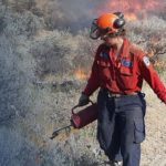
The BC Wildfire Service reports the lightning caused fire, discovered July 8, has been burning in steep and inoperable terrain. An increase in winds is resulting in significant fire behaviour and a column of smoke that is highly visible from Wasa, Cranbrook, Kimberley and surrounding areas. Heavy equipment is being deployed to assist control efforts.
Only 13 km to the southeast is the Tanglefoot Creek fire, discovered July 16. The lightning-caused blaze east of the range is also out of control at 100 ha.
A third, smaller fire continues to burn at Big Lake, but is being held at 11 ha. It is eight km south of Wasa, east of Highway 93/95.
A wildfire discovered yesterday in Flathead Pass, between the Taylor and Flathead Ranges, about two km from the border with Alberta and Castle Provincial Park remains at .1 ha. It is about 30 km southeast of Fernie.
A lightning-caused fire in Dewar Creek, discovered July 16, about 2.5 km west of Price Lake in St. Mary Alpine Provincial Park, about 36 km northwest of Kimberley, is active at 20 ha.
There is another new lightning-caused fire in Ptarmigan Creek, five km north of Whiteswan Lake Provincial Park. The blaze is estimated at .6 ha in size.
A lightning-caused fire first reported last night on Maguire Mountain, about 9.5 km northeast of Grasmere, is being held at 1.1 ha.
The Granite Creek fire in the Purcell Wilderness Conservancy continues to be held at 26 ha.
Five other fires in the East Kootenay are being held or are under control.
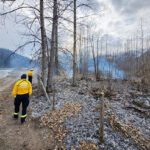
Lead image: The Bill Nye Mountain wildfire burning seven kilometres southeast of Wasa. Nowell Berg Photo
e-KNOW