Home »
The next few weeks could be sandbag weather
 “Perceptions” by Gerry Warner
Op-Ed Commentary
For B.C. flood watchers, the next few weeks could be critical.
In case you haven’t noticed, flooding has already begun at several locations around the province including the Kootenays, Boundary, Okanagan and Cache Creek where the Bonaparte River surged across the Trans-Canada Highway this week closing it down and forcing a motel to be evacuated because of the rising torrent.
Traffic was cut to Cranbrook Thursday when a mudslide crossed Highway 3 between Creston and Salmo. Another mudslide cut off Highway 3 near Cawston west of Osoyoos. Mud slides thundered down all week around the province.
But this could only be the beginning.
A cold, late spring left a deep snowpack on most B.C. mountain ranges this year. This delayed the annual spring runoff, which usually gets underway by mid-April, but is just starting now. Combined with record hot temperatures in early May and you have the formula for a disaster.
The BC River Forecast Centre will issue its monthly bulletin any day now giving a strong indication of what to expect. If it’s hot weather and rain-laden thunderstorms it will not be good news. The best forecast now would be for alternating periods of warm and cool weather that will cause the high mountain snowpack to melt in stages and prevent a major flood.
But if the spring freshet comes down in one giant swoosh there’s going to be trouble. And lots of it.
And it’s happened before.
The biggest flood in memory in BC was in 1948 when similar weather conditions triggered mammoth flooding all over the province especially in the Fraser Valley. Dikes broke in Mission and the lower Fraser River became a giant lake stretching to the base of the steep mountains lining the valley on both sides. Damage was in the millions.
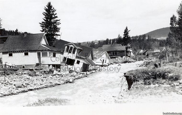
Some 2,300 homes were destroyed, 16,000 people displaced and 10 people were killed. As was the case in 2021 tremendous numbers of livestock also drowned. The Trans-Canada Highway was closed for weeks stranding families all through the province and trains couldn’t help because both major rail lines were washed out. Mark Creek went on the rampage in Kimberley with several homes washing down the angry creek.
But as horrific as this was, the 1948 B.C. flood was not the greatest in B.C. history. That dubious title goes to the Great Flood of 1894 which pounded all of B.C. and the Pacific Northwest including Alberta, Washington and Oregon.
Climate experts say such a flood occurs only once in 200 years and causes damage on an unprecedented scale. An Environmental Ministry document called “Flooding and Landslide Events Southern British Columbia 1808 – 2006,” reads like Noah’s Diary: “The flood of 1894 also caused havoc around the province and the Lower Mainland. Floods on the Columbia River were interrupting rail traffic at Golden . . . at Matsqui the water was up to the top of the telegraph poles . . . On May 31 in Vancouver, the Fraser River, with large amounts of debris, backed up into Burrard Inlet . . . mail from Vancouver and Victoria for eastern points were (sic) forwarded via San Francisco . . . All bridges on the Kettle River were lost . . . Almost all bridges were swept away near Chilliwack . . . Col. James Baker (that’s our Col. Baker, who was Provincial Secretary at the time) reported on the evening of June 4 he was able to pull in a boat up to the Queen’s Hotel (in Chilliwack) . . . a series of washouts on the CPR line west of the Rocky Mountains severed train connections with Eastern Canada for 41 days . . .In the Fort Steele District, four bridges were carried away.”
I’m not trying to scare anyone with this historic nugget, but it’s the official record and I think it provides valuable information on the situation we’re now facing. At the very least, high water is already occurring in BC and there could be more to come. But, in all likelihood, as mentioned earlier, the runoff will likely occur in stages and an extreme flood will be avoided.
But in the end it’s all up to Mother Nature and our civilization hasn’t been treating her too kindly the last century or so. Time will tell.
Lead image: Mark Creek in Kimberley flooding in 1948. Columbia Basin Institute of Regional History photo
– Gerry Warner is a retired journalist, who always has his eye on the weather.