Home »
Groundwater report flags at-risk aquifers
Submitted by Living Lakes Canada
Beneath the communities, farms, and ecosystems of the Columbia Basin lies a hidden lifeline: groundwater. A new scientific assessment commissioned by Living Lakes Canada (LLC) finds that the majority of the region’s high-risk aquifers are unmonitored. This data gap limits the information available for long-term water security planning.
The assessment, summarized in Living Lakes’s latest Watershed Bulletin, provides one of the most comprehensive looks at aquifers in the Basin to date. Aquifers – underground layers of rock, gravel, or sand that store groundwater – are a primary water source for many rural households, farms, and businesses in the region.
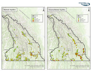
The findings show that 15% of mapped aquifers were flagged as high priority for monitoring based on factors such as water demand, proximity to communities, and agricultural use. Alarmingly, 80% of these high-priority aquifers are not currently monitored at all, despite their importance for local communities.
Several at-risk aquifer “hotspots” critical to agricultural and community water supplies were identified, including the Baynes Lake area, the Sparwood and Fernie areas, and southwest of Golden.
Another critical hotspot near Creston is already being monitored by Living Lakes and the Province of B.C., while the remaining hotspot areas currently have no groundwater monitoring in place.
“For years, we’ve voiced concerns about groundwater uncertainty in our community,” said Stan Doehle, Regional District of East Kootenay Electoral Area B Director and resident of the Baynes Lake area. “To have that validated by a formal scientific assessment is incredibly powerful. This report shows the desperate need for the sustained monitoring we’ve been advocating for, and a path toward protecting our water for future generations.”
Groundwater monitoring helps predict whether a well’s water supply is declining and at risk of going dry – information that is critical for informed water-use decisions, particularly during drought.
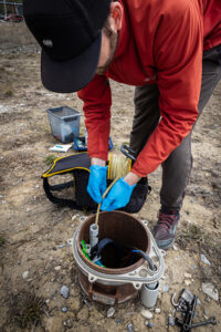
Through the Columbia Basin Groundwater Monitoring Program, Living Lakes partners with 32 well owners to track seasonal and annual changes in groundwater levels. This monitoring program has been designed to complement the eight wells monitored by the Provincial Groundwater Observation Well Network across the region.
The most recent Watershed Bulletin highlights the value of existing groundwater monitoring and summarizes findings from the assessment that will inform future decisions about where to focus new monitoring to address key data gaps.
“By strategically expanding monitoring in those hotspot areas, we can support more informed, data-driven decisions that ensure safe and equitable access to freshwater,” said Arlo Bryn-Thorn, Program Manager with Living Lakes Canada.
Read the complete Watershed Bulletin published by Living Lakes Canada.
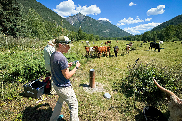
Lead image: Volunteer well owners assist Living Lakes monitoring technicians with collecting groundwater level data from their well. Photo by Steve Edworthy