Home »
Rocky Mountain Forest District access restrictions amended
Due to recent changes in weather and fire behaviour, the closure of the Rocky Mountain Forest District will be rescinded effective at 1 p.m. today, Friday, Sept. 15.
However, the campfire ban and off-road vehicle (ORV) prohibition remain in effect for the entire region. For more information about the ORV prohibition.
The following area restrictions replace the district-wide closure and will remain in effect until the public is otherwise notified.
1. An area restriction applies to Crown land within the areas of the White River wildfire and the Quinn Creek wildfire. The area restriction follows the western boundary of Height of the Rockies Provincial Park in the north and the junction of Bull River Forest Service Road and Sulfur Creek Forest Service Road in the South. The area restriction boundary then follows the height of land between Bull River and Elk River west to the height of land west of Lussier Creek. The area restriction boundary then extends north to include the White River Forest Service Road and over Mount Dorman to the headwaters of the Palliser River in Height of the Rockies Provincial Park. A detailed map of the affected area is available online.
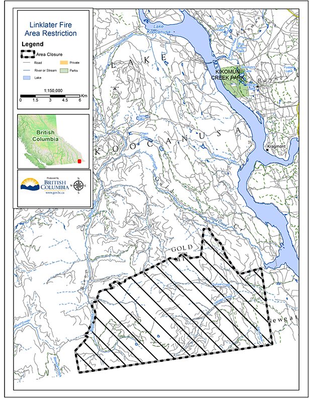
2. An area restriction applies to Crown land within the area of the Linklater wildfire. The area restriction boundary (pictured above) extends northeast from the Canada-United States border where it meets Bloom Creek, along that creek to Gold Mountain, then east and south to the point where the Meadow Creek Forest Service Road meets Kikomun-Newgate Road, and then south to the border and along the border to Bloom Creek. A detailed map of the affected area is available online.
3. An area restriction applies to Crown land encompassing the Flathead region. The area restriction boundary runs from the Corbin Mine site on the eastern border of British Columbia south to the Canada-United States border. The area restriction boundary then runs west along that border to the height of land west of the Wigwam River and north along a defined gas line running northeast to Leach Creek and northeast to the Corbin Mine site. For more information
The area restriction includes the following fires:
– Soowa Mountain
– Lodgepole
– Cabin Creek
– Elder Creek
– Kenow Mountain
– McLatchie Creek
– Pollock Creek
– Centre Mountain
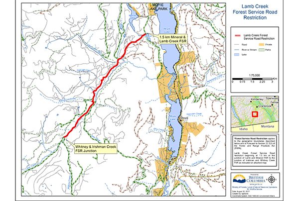
4. An area restriction remains (map shown above) in place for the Lamb Creek wildfire.
See a factsheet about these forest district closures.
In addition, several forest service road closures remain in place to restrict access in the vicinity of active wildfires in the Southeast Fire Centre. For more information regarding these road closures.
Under the Wildfire Act, a person must not remain in or enter these restricted areas without prior written authorization, unless the person enters the area only in the course of:
- travelling to or from his or her residence that is not under an evacuation order;
- using a highway as defined in the Transportation Act;
- travelling as a person acting in an official capacity; and
- travelling for the purpose of supporting wildfire suppression activities.
Evacuation orders and evacuation alerts issued by the Regional District of East Kootenay remain in place. For more information about these alerts and orders, please visit: https://www.rdek.bc.ca/
The Southeast Fire Centre extends from the U.S. border in the south to the Mica Dam in the north and from the Okanagan Highlands and Monashee Mountains in the west to the B.C.-Alberta border in the east. The Southeast Fire Centre includes the Selkirk Natural Resource District and the Rocky Mountain Natural Resource District.
To report a wildfire or open burning violation, call *5555 on a cellphone or 1 800 663-5555 toll-free. For the latest information on current wildfire activity, burning restrictions, road closures and air quality advisories, visit: www.bcwildfire.ca
Ministry of Forests, Lands, Natural Resource Operations and Rural Development and BC Wildfire Service