Home »
Area restriction in effect for Ravens Head area
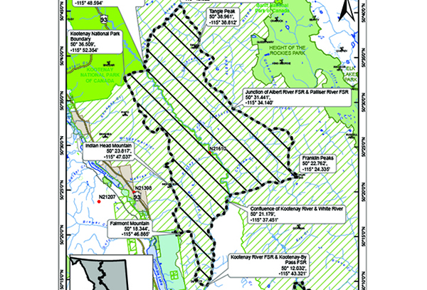
The BC Wildfire Service continues to respond to the Ravens Head wildfire (N21610), located about 20 km east of the district of Invermere, and about 16 km northeast of Highway 93/95. The size is estimated to be 4,702 hectares.
In the interest of public and responder safety, an area restriction is now in effect within the Ravens Head area:
- Commencing at the junction of Kootenay River FSR & Kootenay By-Pass FSR @ [50° 12.032′, -115° 43.321′],
- travelling North along the Kootenay River to the confluence of Kootenay River & White River @ [50° 21.179′, -115° 37.451′].
- Turning East and following the height of land tying into Franklin Peaks @ [50° 22.762′, -115° 24.335′],
- continuing North along the height of land crossing over the junction of Albert River FSR & Palliser River FSR @ [50° 31.441′, -115° 34.140′].
 Continuing North/Northwest tying into Tangle Peak @ [50° 38.961′, -115° 38.812′],
- continuing along height of land to the confluence of Cross River & Mitchell River @ [50° 43.766′, -115° 40.822′].
- Turning South/Southwest following along Cross River to the confluence of Kootenay River & Cross River @ [50° 37.807′, -115° 48.594′],
- meeting the outer boundary of Kootenay National Park.
- Following the outer boundary of Kootenay National Park to [50° 36.509′, -115° 52.354′],
- turning South/Southeast following along the height of land tying into Indian Head Mtn Peak @ [50° 23.817′, -115° 47.037′].
- Continuing South along the height of land tying into Fairmont Mtn Peak @ [50° 18.344′, -115° 46.885′],
- continuing to the point of commencement at the junction of Kootenay River FSR @ Kootenay By-Pass FSR @ [50° 12.032′, -115° 43.321′].
Under this Order and section 11(2) of the Wildfire Act, a person must not remain in or enter the restricted area, unless the person:
1.) first receives written authorization of an official designated for the purposes of the Wildfire Act, or
2.) enters the area only in the course of:
(a) travelling to or from his or her principle residence, that is not under an evacuation order;
(b) using a highway as defined in the Transportation Act;
(c) travelling as a person acting in an official capacity as defined in s.56 of the Wildfire Act; or
(d) travelling for the purpose of supporting wildfire suppression or enforcement patrol activities.
A detailed map of the affected area is available HERE.
Road closures and area restrictions are subject to change depending on fire activity. For the most current information please visit the bans and restrictions section of the BC Wildfire website for the Southeast Fire Centre.
To report a wildfire, unattended campfire or open burning violation, call 1 800 663-5555 toll-free or *5555 on a cellphone. For the latest information on current wildfire activity, burning restrictions, road closures and air-quality advisories, visit: www.bcwildfire.ca or download the BC Wildfire App free for Apple and Android devices.
e-KNOW