Home »

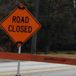
Area restriction in effect for Mount Morro Area
The BC Wildfire Service continues to respond to the Mount Morro wildfire, (N21014), located about 43 km northeast of the City of Kimberley, about 42 km northwest of the city of Fernie, and about 21 km east of Highway 93.
The size is estimated to be 3,700 hectares.
In the interest of public and responder safety, an area restriction is now in effect within the Mount Morro area:
- Starting at the end of Wildhorse Main FSR @ [49° 47.895′, -115° 30.005′],
- heading North following the height of land and crossing the White Ram FSR @ [50° 1.103′, -115° 33.685′],
- continuing along the height of land to the confluence of Lussier River & Fawn Creek @ [50° 7.901′, -115° 35.630′].
- Turning East and running along the White Swan River FSR to [50° 8.015′, -115° 29.288′],
- continuing Southeast along the height of land tying into the peak of Mt Nicholas @ [50° 0.629′, -115° 21.767′],
- continuing to the source of Goathoof creek @ [49° 45.924′, -115° 18.642′].
- Continuing Southwest and tying into the junction of Bull-Galbraith FSR & Galbraith creek @ [49° 44.749′, -115° 20.419′].
- Heading West following the height of land and tying back into the point of commencement at the end of Wildhorse Main FSR @ [49° 47.895′, -115° 30.005′].
Under this Order and section 11(2) of the Wildfire Act, a person must not remain in or enter the restricted area, unless the person:
1.) first receives written authorization of an official designated for the purposes of the Wildfire Act, or
2.) enters the area only in the course of:
(a) travelling to or from his or her residence, that is not under an evacuation order;
(b) using a highway as defined in the Transportation Act;
(c) travelling as a person acting in an official capacity as defined in s.56 of the Wildfire Act; or
(d) travelling for the purpose of supporting wildfire suppression or enforcement patrol activities.
Road closures and area restrictions are subject to change depending on fire activity. For the most current information please visit the bans and restrictions section of the BC Wildfire website for the Southeast Fire Centre.
The Southeast Fire Centre extends from the U.S. border in the south to Mica Dam in the north, and from the Okanagan Highlands and Monashee Mountains in the west, to the B.C.-Alberta border in the east.
To report a wildfire, unattended campfire or open burning violation, call 1 800 663-5555 toll-free or *5555 on a cellphone. For the latest information on current wildfire activity, burning restrictions, road closures and air-quality advisories, visit: https://www.bcwildfire.caor download the BC Wildfire App free for Apple and Android devices.
BC Wildfire Service,
Southeast Fire Centre