Home »

BCWS managing three wildfires of note
There are currently three wildfires of note burning in the East Kootenay, not including the Wardle Creek fire in Kootenay National Park.
The largest of the three is the Sage Creek wildfire, located approximately 65 km south east of Fernie and approximately six km southwest of the B.C.-Alberta border.
Discovered August 2, the fire is now 1,148 hectares in size.
“This fire is a modified response fire meaning it is managed using a combination of suppression techniques, including direct and indirect attack, and monitoring to steer, contain and otherwise manage fire activity within pre-determined perimeters. This type of response is used to minimizes costs and/or damage and to maximize benefits from the fire,” explained the BC Wildfire Service (BCWS)
The Flathead Sage Creek Forest Service Road remains closed starting at the 81 kilometre mark at the junction of Flathead Kishinena Forest Service Road and the Flathead Sage Forest Service Road. No access is permitted on this section of road. This road will remain closed until the public is otherwise notified.
Today there are 69 firefighters, eight helicopters, three pieces of heavy equipment and one airtanker fighting the fire, which is burning in remote terrain.
Crews are working to reinforce the Flathead Sage Forest Service Road as a guard on the north end of the fire. The south side of the fire is burning upslope and connecting with the fuel break created from the Kenow Mountain wildfire from 2017.
An Alberta Incident Management Team (IMT) is on site of this fire.
This fire is producing a large column of smoke that is highly visible from Pincher Creek in Alberta and surrounding areas.
Crews are planning for future burn off operations. Expect to see additional smoke from this fire in the coming days, BCWS alerted.
Heavy equipment will continue constructing dozer lines. Crews will provide support with pump and hose. Aerial suppression will continue to limit further spread along the perimeter.
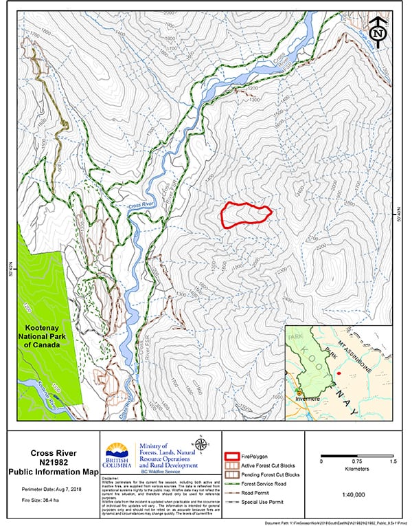
The fire causing the most concern today is the Cross River wildfire, which has promoted an evacuation alert for nine properties in the area, including Nipika Mountain Resort.
The approximate 36.4 ha fire is approximately nine km east of Highway 93, and about 23 km northeast of the Village of Radium Hot Springs.
Discovered August 1, the lightning-caused fire has forced, effective immediately, the closure of the Cross River Forest Service Road starting at the 16 kilometre mark running to the Cross/Mitchell River Forest Service Road. This road closure applies to all non-industrial road traffic.
“This fire is a modified response fire meaning it is managed using a combination of suppression techniques, including direct and indirect attack, and monitoring to steer, contain and otherwise manage fire activity within pre-determined perimeters,” BCWS reported.
This fire is burning in steep and difficult terrain and is being closely monitored.
And the Whitetail Creek wildfire (pictured right below) east of Spillimacheen, on the boundary of Kootenay National Park, is considered 55% guarded and 40 contained. Discovered July 27, the lightning-caused wildfire is now 283 ha in scale.
“This fire is classified as out of control. This is a modified response fire. The fire is being managed using direct and indirect attack management tactics and fire behaviour monitoring to contain the fire within pre-determined perimeters. This type of response is used to minimise costs and damage, and to maximize ecological benefits from the fire,” BCWS stated.
 There are 63 firefighters, three helicopters and four pieces of heavy equipment on the fire today.
Crews are reinforcing machine guards and extinguishing hotspots to limit fire growth. Air resources continue to bucket hotspots.
This wildfire does not pose a threat to any communities at this time. This fire does not currently pose a risk to visitors of Kootenay National Park; however, as a precautionary measure, area closures and smoke advisories have been put into place by Parks Canada.
The Beaverfoot Forest Service Road is closed beyond the 47-kilometre mark (near the Symond Creek Bridge). No access is permitted on this section of road. This road will remain closed until the public is otherwise notified.
A Parks Canada Incident Management Team (IMT) is on site of this fire.
Other wildfires in the East Kootenay noted by BCWS:
- Bull FSR: A two ha in size person-caused fire discovered August 7.
- Kilmarnock Creek- Modified Response: A 4.1 ha lightning-caused fire discovered on August 6 – located about 16 km northeast of Elkford, on the east side of the Fording River.
- Akenside Creek – Modified Response: A 133.8 ha lightning-caused wildfire discovered on July 31. The fire is about 16 km west of Spur Valley, and south of the Frances Creek drainage.
- Hog Ranch – Modified Response: Discovered July 20, this lightning-caused fire remains at 43.6 ha and is listed as active about eight km northeast of Parson.
- Baird Brook: Discovered August 7, this lightning-caused fire is about eight ha in size and is located in the high country near the end of the Spillimacheen River drainage.
- Dally Hill: An active .15 ha fire, about one km south of Cabin Creek (east of the Flathead Valley) believed to have been started by lighting on August 6.
With increasingly hot and dry weather, wildfires can change rapidly. If you are planning to enter the backcountry, please maintain situational awareness of existing wildfires and avoid areas with active firefighting operations.
Lead image: BCWS staff mapping the Whitetail Creek wildfire. BCWS images
e-KNOW