Home »

Cummings Creek wildfire added as fire of note
As of this morning (August 7) there are now three wildfires of note in the East Kootenay and one new fire, according to BC Wildfire Service (BCWS).
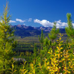
Joining the Connell Ridge and Weasel Creek wildfires on the list is the Cummings Creek wildfire, about five km west of Sparwood. Discovered August 3, the suspected lightning-caused fire is now an estimated 13 hectares.
“The fire is currently burning in extremely steep, inoperable terrain where it is unsafe for crews or equipment to work on suppression activities. Operations staff are observing the fire daily for ongoing data gathering and to determine the response strategy for the best chance of success,” BCWS reported, adding it will be working closely with the local fire departments and the Regional District of East Kootenay to assess response efforts.
The Incident Management Team assigned to the Connell Ridge wildfire and the Weasel Creek wildfire has taken over control of the Cummings Creek wildfire and resources will be shared between the three incidents as required.
“Due to the relative inaccessibility of water sources suitable for helicopter bucketing and the inability for crews to support on the ground suppression currently, it would not be effective at this time to attempt bucketing suppression efforts,” BCWS stated.

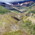
The Connell Ridge wildfire (pictured right), discovered August 1 about 15 km south of Cranbrook, is still an estimated 1,350 ha, as reported yesterday afternoon.
“The north and northeast section of the fire is burning in steep and inoperable terrain. Crews and equipment are making good progress on the construction of containment lines around the southeast, south, west, and northwest flanks of the fire,” BCWS reported.
“Crews will be working on conducting minor ignition operations along the fire perimeter where appropriate. Equipment is also working on the north flank of the wildfire to build containment lines.”
As of today, 69 firefighters, 35 pieces of heavy equipment and seven helicopters are actioning the largest blaze in the region.
An Evacuation Alert has been issued by the Regional District of East Kootenay in the vicinity of this fire.
And an Area Restriction is in effect for this incident in order to protect the public in areas where ongoing fire suppression activities are taking place.

Finally, the third wildfire of note in the region, the Weasel Creek fire, located in both the US and Canada, about 22 km east of Roosville, two kilometres west of Frozen Lake and 39 kilometres southeast of Baynes Lake, is now a combined 965 ha, with 482 ha burning in British Columbia.
The fire crossed the Canada–United States border on the afternoon of August 4, and is currently burning into the Flathead Valley, two kilometres west of Frozen Lake.
The suspected lightning-caused fire was initially discovered in the United States on July 30.
“The size of the wildfire has changed slightly upon further coordination and more accurate mapping being provided to us from the United States Incident Management Team. There was some overall growth on the Weasel Creek wildfire today, however the Infrared Scan completed by the US IMT last night has provided us a more accurate map of the portion of the fire burning within Canada,” BCWS reported.
A new lightning-caused fire is reported on Mount Nicholas, about 12 km northeast of Top of the World Provincial Park. The fire is an estimated 2.1 ha.
The Mount Docking wildfire, about 28 km east of Radium Hot Springs, is still out of control at 13.4 ha. Discovered July 30, it is suspected lightning-caused the fire.
The Gilnockie Provincial Park fire, ignited by lightning on August 4, is still out-of-control at .44 ha. The fire is about 24 km east of Yahk.
The Stair Lakes fire, located in St. Mary’s Alpine Provincial Park about 28 km northwest of Kimberley, remains out of control at 64.8 ha. The suspected lightning-caused fire was discovered July 31.
Lead image: The Cummings Creek wildfire as of August 6. BC Wildfire Service photo
e-KNOW