Home »

Special weather statement for Kootenay Pass
Environment Canada has today (May 19) issued a special weather statement warning of wet snow near highway summits, including Paulson Summit to Kootenay Pass.
A Pacific front is approaching the southwestern B.C. Interior this morning. Wet snow is expected over the highway summits as snow levels will be near 1,200 metres initially, Environment Canada reported.
“Snowfall accumulations from trace to five cm are expected this morning. As snow level rises to above the summits this afternoon, snow will then change to rain, but wet snow may return tonight as snow level falls again.
“Over Paulson Summit and Kootenay Pass, wet snow will start near the pass this afternoon and continue through Tuesday (May 20). Snowfall accumulations from trace to five cm are expected through this evening. Additional amounts over 5 cm are possible on Tuesday.”
Please be prepared to adjust your driving as weather conditions at high elevations may change quickly. Slow down and maintain a safe following distance.
Weather in the mountains can change suddenly resulting in hazardous driving conditions. Road conditions are available at drivebc.ca.
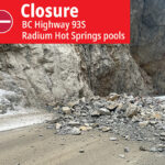
e-KNOW file photo