Home »
Touchy conditions for the Interior and southeast
By Avalanche Canada
Touchy, sketchy, spicy, spooky… whatever you want to call it, the snowpack in B.C.’s interior and southeastern regions is dangerous right now.
A series of persistent weak layers lurks within the top metre of the snowpack and is primed for human triggering.
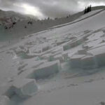
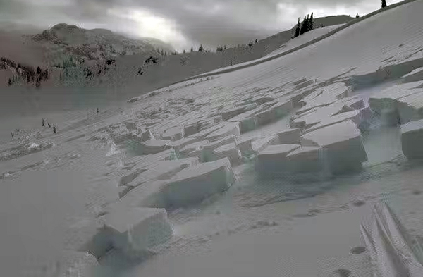
Avalanches on these layers are being reported on surprisingly low-angle slopes, and remote triggers have also been observed. These are classic signs of an unstable snowpack and mean we must be much more conservative in our choices. The problem is most notable at treeline on north through east aspects.
Heading into this weekend, and likely into the coming week(s), we need to make sure we’re shifting our plans to align with this volatile and complicated snowpack. Persistent slabs are famously tricky to manage–they’re hard to predict, especially when remote triggering is possible, and we don’t always get good feedback to make decisions.
Slopes might not release on the first run, or even the twentieth, but that doesn’t mean they can’t.
With this kind of snowpack, the best way of managing the problem is avoiding it. That doesn’t mean staying out of the mountains, but it does mean avoiding terrain that could produce an avalanche large enough to bury you or someone in your group. Look for low-angle slopes that are too small to produce a dangerous avalanche and stay away from places with overhead hazard or terrain traps.
These difficult conditions won’t last forever, but they are here for the next little while. Stay patient and play it safe for now—the bigger lines will still be there when things improve.
Lead image: Avalanches are possible on surprisingly low-angle slopes. Photo from the central interior region on Thursday, February 19. Avalanche Canada photo