Home »

Wildfire update for the East Kootenay
With unfavourable hot, dry and windy weather forecast for the next day, the numerous battles on wildfires burning in the East Kootenay could face various challenges.
“This weather may result in intense, unpredictable and dangerous fire behaviour. Existing fires may challenge guards and response efforts and could change directions suddenly. New fires may grow quickly,” BC Wildfire Service (BCWS) warned today (August 17).
“Hot temperatures and low to very low humidities are expected today. Winds should increase through the afternoon, remaining elevated into or through the night out of the southwest or west. A maximum temperature of 32 and minimum relative humidity of 16% during the day, a low of 22 and maximum relative humidity of 32% overnight.”
In this video, Neal McLaughlin, BCWS superintendent of predictive services, explains the anticipated conditions and their impact on fires across B.C.
Horsethief Creek Complex
Horsethief Creek/Bruce Mountain; Mia Creek; Yearling Creek wildfires
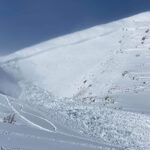
 The Horsethief Creek/Bruce Mountain Wildfire, seven km north of Panorama and 10 km west of Invermere is today 3,918.5 hectares in size.
An evacuation alert was issued by the Regional District of East Kootenay (RDEK) today covering 926 properties at Panorama Mountain Resort and all properties along Toby Creek Road southwest of Lillian Lake, including Lanac Road, Neave Road, and Hydro Substation Road.
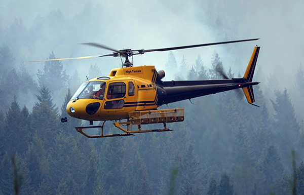
There are 57 firefighting personnel responding to this fire. There are currently four pieces of heavy equipment with operators responding to this wildfire.
There are 12 helicopters shared between the Horsethief Complex, which includes the Horsethief Creek (N22243), Yearling Creek (N21453) and Mia Creek (N22240) wildfires.
Yesterday, the Horsethief Creek fire grew in the Bruce and Law drainages.
Today crews will be focused on moving equipment to safe areas and preparing for defensive actions.
“Isolated thunderstorms are possible in the Invermere area late Thursday afternoon and into the evening,” BCWS noted.
“A cold front pushing through the area Friday should continue to support elevated, gusty winds, shifting to northerly Friday morning.”
Currently, Area Restrictions are in place over and around the Horsethief Creek and Mia Creek fires and the Cochrane Creek FSR, on the southern border of the Yearling Creek fire, is closed to the public. These restrictions and closures must be respected for the life safety of our responders and members of our community.
Approximately 17 kilometres northeast of Canal Flats, the Mia Creek Wildfire, discovered July 24, is now an estimated 3,473.4 ha.
The lightning-caused fire remains out-of-control as 32 firefighting personnel respond to it.
There are currently eight pieces of heavy equipment responding to this wildfire.

The Yearling Creek Wildfire, discovered July 9 about 20 km east of Radium Hot Springs, is today 2,946.6 ha.
BCWS reports 37 wildfire suppression personnel are assigned to this incident along with two pieces of heavy equipment.
“Over the coming days, firefighters, heavy equipment and aviation resources will continue to respond to the Horsethief complex, but safety will remain the top priority. As we may see over the coming days, wildfires can be dynamic and unpredictable but we can each take the time to prepare ourselves, our families and our communities in the event we are threatened by a wildfire, community preparedness benefits us all,” BCWS stated.
There are 26 firefighters responding to this wildfire, along with six helicopters and 15 pieces of heavy equipment.
Lladnar Creek Wildfire
Discovered July 21 close to Sparwood, this wildfire is now 1,246 ha.
 “Fire behaviour has remained minimal in the past day. On Wednesday, crews successfully conducted some small-scale planned ignitions on pockets of remaining fuel. Containment lines to the south and east of the fire are complete and ongoing patrols have not seen any areas of concern on the east flank for several days. On Tuesday, the fire remained within these established containment lines despite stronger winds and increased fire behaviour,” BCWS reported this afternoon.
“Firefighters continue to mop up and strengthen and reinforce containment lines in anticipation of winds Thursday afternoon through Friday. Aviation and heavy equipment remain on site to support ground crews as required.
“Increased smoke and fire behaviour, particularly to the north of the fire, is expected during periods of elevated winds. Crews will work overnight Thursday to Friday to monitor the fire and respond as required. Structure protection specialists continue to monitor and patrol. The safety of the public and first responders is the top priority.
“Heavy smoke in the valley is coming from large fires burning to the northwest in the Kamloops Fire Centre.”
There are 46 firefighters and operational support personnel responding to this fire, along with six helicopters and two pieces of heavy equipment.
Mount Bingay Wildfire
Discovered 16 kilometres northwest of Elkford on August 6, the out-of-control fire is 403.3 ha.
“The fire has grown to the east, crossing the Elk River Forest Service Road. It remains west of the Elk River. Structure protection is in place to the north of the fire where required,” BCWS explained.
“Crews have completed a guard to the south of the fire on the west side of the Elk River and are line-locating and building guard on the east side. Further contingency lines to the south of fire are expected to be complete Thursday afternoon in anticipation of forecast elevated winds Thursday night into Friday. Work is underway to protect hydro lines on the east side of the river in the event the fire spread in that direction.
“Crews will work overnight Thursday to Friday to monitor the fire and respond further if required. The safety of the public and first responders is the top priority.
“Increased smoke and fire behaviour, particularly to the north of the fire, is expected during periods of elevated winds. Open flame, candling and glowing may be visible from Elkford and surrounding communities Thursday night. Crews will be monitoring the fire overnight and are prepared to respond as required. Structure protection specialists continue to monitor and patrol.”
An area restriction is in effect in the vicinity of the Mount Bingay wildfire. For more information, click here.
Lum Creek Wildfire
Discovered July 30 on Fisher Peak approximately 25 kilometres northeast of the City of Cranbrook, this fire is now 843 ha.
BCWS reported it is burning at high elevation in steep, inoperable terrain. Smoke may be visible intermittently from Cranbrook and surrounding areas.
“This fire has displayed increased activity in recent days as a result of hot, dry conditions in the area and intermittent elevated winds. It is not threatening any structures or communities at this time.
The BC Wildfire Service is monitoring this fire to manage it as required to minimize disruption and negative impacts while allowing the natural ecological benefits of wildfire to occur. Learn more about response types here. Plans are in place to actively suppress this fire and protect structures in the vicinity if required.
For public safety, an area restriction is in effect in the vicinity of the fire. Information on the restriction can be found here and a map of the affected area can be viewed here.
Kamma Creek Wildfire
Discovered July 19 approximately 27 kilometres west of Moyie Lake and 37 kilometres southwest of Cranbrook, the out-of-control fire is now 659 ha.
The fire is burning in a remote area where it is not currently threatening structures, communities or infrastructure.
The fire has displayed increased fire behaviour this week due to hot, dry conditions and intermittent elevated winds. Increased smoke has been visible and will likely continue, BCWS said.
An area restriction is in effect in the vicinity of this wildfire.
Jubilee Mountain Wildfire
Discovered July 31 northwest of Spillimacheen, the out-of-control fire is 921 ha.
Castle Mountain Wildfire
Discovered July 22 northeast of Spillimacheen, the out-of-control fire is now 449 ha.
Raymond Peak Wildfire
Discovered August 6 about 11 km southeast of Elko, the out-of-control fire is 60 ha.
Click to here to learn about the six area restrictions in place in the region.
The BC Wildfire Service would like to remind the public to stay clear of active work zones for these fires.
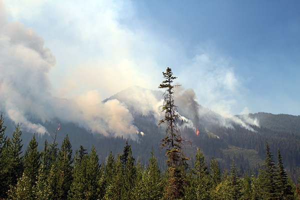
Lead image: BCWS firefighters conducted small-scale planned ignitions July 16 on the Lladnar Creek wildfire near Sparwood. BCWS Photos
e-KNOW