Home »
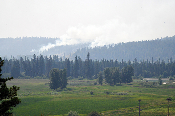
Wildfire update for the East Kootenay for July 28
The following is an update of the fires-of-note and other large wildfires in the East Kootenay for July 28, from information reported by BC Wildfire Service (BCWS)
St. Mary River Wildfire
The St. Mary River Wildfire is today (July 28) 4,640 hectares.
“The increased fire size is due to successful planned ignition operations, which removed unburnt fuel between the fire edge and guards in an intentional manner to minimize the risk of the fire spreading beyond control lines. It is not a result of any new outward fire growth or increased fire behaviour,” BCWS explained.
“Fire activity remains observed as a smouldering ground fire (rank 1). All control lines continue to hold. Planned ignitions are continuing Friday as conditions allow. Saturday is forecast to be hotter and drier with a slightly higher chance of a thunderstorm.
“On Friday, firefighters continue work to secure guard along the fire’s east and west flanks using small-scale hand ignitions. These operations, which began Wednesday, remove unburnt fuel between the fire edge and guards in an intentional manner to reduce the chance of the fire spreading beyond control lines. Intermittent increased smoke will continue to be visible to the surrounding communities during these operations.
“The BC Wildfire Service is working with local governments on the process of reviewing and lifting evacuation alerts and orders as soon as it is safe and practical to do so.
Elsewhere on the fire, crews continue to mop up and patrol.
Evacuation Orders and Alerts
Evacuation ALERTS and ORDERS for The ʔaq’am community have been updated as follows.
The Regional District of East Kootenay has an evacuation ALERT in effect as follows.
Bruce Mountain Wildfire
The Bruce Mountain Wildfire west of Invermere is today 1,020 ha.
“Higher humidity and lower temperatures have helped reduce the fire activity since Wednesday. The forecast calls for a warming and drying trend as a four corner ridge builds, though the risk of thundershowers persists,” BCWS said.
“Machine guard has been established from the Bruce FSR to Toby Creek; guard is now established along the BC Hydro access road. Ground crews are making control lines by hand, removing the fuels in an avalanche chute on the East flank to bolster the natural control lines. Direct attack of the fire will be undertaken where conditions allow.
“Indirect attack strategies, including small scale hand ignitions to reinforce control lines will be ongoing. Ignitions will begin today, an increase in smoke may be noticeable to surrounding communities during these intentional operations.
“With the support of heavy equipment and bucketing by helicopters, ground crews continue to use direct, parallel and indirect fire suppression methods at key areas of the Horsethief Creek wildfire perimeter to establish control and contingency lines to protect properties, infrastructure, and timber.
“Structure protection personnel and local fire departments are working together to assess, set up, and install equipment on areas of potential concern.
Evacuation Orders and Alerts
The Regional District of East Kootenay has issued an evacuation ORDER and ALERT as follows.
Lladnar Creek Wildfire
The Lladnar Creek Wildfire adjacent to the District of Sparwood is today 379.9 ha.
The fire is a smouldering ground fire (rank 1 and 2) with pockets of rank 3 in areas of heavy fuel accumulation.
“Southward growth has been minimal. On the north side, the fire continues to progress downslope into Matevic Draw. On the east flank, the fire is slowly moving downslope and meeting the control line,” BCWS stated.
“Guards are complete from Cummings Creek in the north to Lladnar Creek in the south. On Friday, crews continue small-scale hand ignitions to anchor the fire to the guard. This tactic removes unburnt fuel between the fire edge and control lines in an intentional manner to reduce the chance of the fire spreading beyond control lines.
“Firefighters are also establishing water-delivery systems and hoselay in critical areas.
Structure protection personnel are on site, developing plans to install equipment as a precautionary measure if needed in Sparwood Heights and other areas of concern.
“Saturday brings hotter, drier temperatures with a slightly greater chance of a thunderstorm.”
The BC Wildfire Service reported it is increasing resources in the Sparwood area. The increased presence of BCWS personnel, equipment, operational staff and others related to firefighting efforts will be visible to the community in the coming days.
For the most recent video update on operations with BCWS Incident Commander Daniel Klein and Regional District of East Kootenay Communications Manager Loree Duczek, click here.
An Incident Command Post is established at the Sparwood Recreation and Leisure Centre, which is hosting approximately 125 personnel responding to this fire.
For information on any impacts to usual operations at the leisure centre, please visit the District of Sparwood website.
The District of Sparwood has issued an evacuation ALERT due to this wildfire. For the latest information on evacuation alerts and orders, visit the District of Sparwood website.
While the BC Wildfire Service recommends evacuation orders and alerts, local authorities are responsible for implementing them. For more information on the evacuation alert due to the Lladnar Creek Wildfire, visit the District of Sparwood website
Yearling Creek Wildfire
Yearling Creek Wildfire 25 km east of Radium Hot Springs remains at 1,175 ha.
“Higher humidity and lower temperatures have helped reduce the fire activity since Wednesday. The forecast calls for a warming and drying trend as a four corner ridge builds, though the risk of thundershowers persists,” BCWS said.
“This is a modified response fire, which means that personnel are using a combination of suppression techniques, including direct and indirect attack as well as monitoring to steer, contain and otherwise manage fire activity to minimize damage while maximizing the benefits of fire on natural ecosystems. Learn more about direct and indirect attack strategies.
“Structure protection specialists are on site to assess and, if required, install structure protection equipment in order areas to protect residences and other infrastructure that are potentially impacted by this wildfire.
“Personnel and heavy equipment are making progress putting in guard lines and tying into the Yearling Creek drainage to prevent the fire from coming into closer proximity to properties and other values.
“Crews will be looking for opportunities to conduct small-scale hand ignitions to remove unburnt fuel between the fire edge and control lines in an intentional manner to reduce the chance of the fire spreading. If weather and site conditions align, small scale ignitions will proceed in areas to reinforce control lines.”
Evacuation Orders and Alerts.
Mia Creek Wildfire
The Mia Creek Wildfire, about 15 km northeast of Canal Flats, is reported at 881 ha today. The out-of-control fire is getting a full response from BCWS.
e-KNOW file photos
e-KNOW