Home »
Work continues on region’s two fires of note
The Bill Nye Mountain Wildfire, burning since about July 8 seven km southeast of Wasa, is now an estimated 1,918 hectares.
“On Tuesday evening, wind and terrain increased fire behaviour on the north flank, where planned ignitions on July 25 could not be completed, and caused the fire to move downslope toward Lazy Lake Road. This prompted an expansion of an evacuation order for properties in the area,” BC Wildfire Service (BCWS) July 28 reported.
“While structures are not immediately threatened, the BC Wildfire Service recommended the evacuation order due to the potential for the Lazy Lake Road to be impacted, which would affect access and egress to these properties.
“Fire behaviour on the western flank of the fire, where the July 25 planned ignition was successfully completed, has not seen a significant change. The fire is burning in a steep valley that is difficult for ground crews to access but somewhat sheltered from the current prevailing winds.”
 An evacuation order and an evacuation alert are in effect in the vicinity of this fire.
An area restriction in the vicinity of this fire is in effect.
BCWS reports 40 firefighters, two helicopters and four pieces of heavy equipment are fighjting the fire today.
“Control lines are being laid out and constructed to the north of the fire to protect structures and build toward containment. Helicopters will continue bucketing to support ground crews. Aerial monitoring of the fire is ongoing. Heavy equipment is constructing a machine guard along the west and north flank and around structures,” BCWS said.
Despite the fact the entire East Kootenay is in either extreme or high fire danger, BCWS reports no new fires today.
However, the region’s second fire of note burning in the Mineral Creek area, 25 km southwest of Invermere, remains out-of-control at 103 ha.
“Work continues today to complete the wet line along the south flank. A wet line is comprised of hose or sprinklers that are strategically placed along a control line to keep consistent moisture and humidity in the area. Ground crews will also be intentionally burning a small amount of fuels on the south flank to additionally reinforce that guard,” BCWS reported.
“Work will continue on a hand-built fuel-free guard in the slide chute where it is too steep for machines to operate and retardant will be laid down to reinforce that fuel-free. Work begins to prepare the area for a small, approximately 20-hectare planned ignition in the northeast corner of the fire that will bring the fire down to more workable terrain. This planned ignition will begin on or around July 29, depending on suitable conditions. Helicopters will bucket to help cool pieces of the fire as required.”
Today there are 31 firefighters, two helicopters and three pieces of heavy equipment on the fire.
An area restriction in the vicinity of this fire is in effect. The cause of the fire remains under investigation.
The Tanglefoot Creek fire, discovered July 16 about 15 km southeast of the Bill Nye fire, remains out-of-control but holding in size at 325 ha.
The lightning-caused fire discovered July 16 in Dewar Creek about 2.5 km west of Price Lake in St. Mary Alpine Provincial Park, about 36 km northwest of Kimberley, is still out-of-control at 58 ha.
The nearby fire at Armour Creek, nine km southwest of the Dewar Creek fire and about 26 km northeast of Riondel, is still out-of-control at 72.64 ha.
The lightning-caused Ptarmigan Creek wildfire five km north of Whiteswan Lake Provincial Park remains out-of-control at 62 ha.
The fire along Marian Lake Forest Service Road, eight km northeast of Castledale on the east side of Castle Mountain, is now being held at 40 ha. An area restriction is now in place.
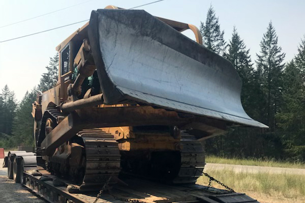
Lead image: Another piece of heavy machinery arrives for duty on the Bill Nye Mountain Wildfire near Lazy Lake July 27. Patty Pukas photo
e-KNOW