Home »

Regional snapshot – 2013 flooding
Saturday, June 22 – 12 p.m.
 Elkford –The District of Elkford is maintaining the State of Local Emergency declared June 20. The Evacuation Order has been rescinded and an Evacuation Alert has been declared in its place. The Reception Centre is no longer open; however, residents impacted can contact Emergency Social Services at 250-603-9934. Highway 43 through Elkford has been reopened to all traffic. Drivers are asked to drive slowly around the barriers near the small amount of water remaining on the road surface. Residents are asked to stay away from the Elk River, Boivin Creek and to stay off the roads and trails north of town. Business owners located on Front Street and Water Street are able to access their buildings but will not have use of sanitary sewer until further notice. Please use caution when entering.
 Sparwood –Residents of the Mountain View Trailer Park who had been evacuated on Thursday were allowed to return home Friday after Michel Creek dropped dramatically. As a result of the lower levels in Michel Creek and Cummings Creek overnight, the evacuation alert for GN Road, Lodgepole Trailer Court and Mountain View Mobile Home Park, is lifted. Residents are reminded that areas that have been flagged off as closed, remain so, until crews are able to inspect and determine that the area is safe to enter. Water levels remain high and the banks are particularly unsafe, as erosion underneath, not visible from the top of bank may have occurred. The properties on Industrial Road #3 and Michel Creek Road will continue to experience lower pressure levels than normal, resulting from the loss of the water line under the Elk River. The Local State of Emergency declared on June 20, remains in effect. Highway 3 east of Sparwood has been opened to two-lane traffic; however, it has been reduced to single lane alternating at the Michel Creek Bridge as crews work to shore up the bridge abutment which has been eroded by high waters.
 Hosmer – Water levels have dropped dramatically. Evacuation orders remain in effect for 88 homes in Hosmer. A 20-person Forestry Unit Crew, firefighters and volunteers are continuing with sandbagging efforts to ensure a stockpile is ready to go should it be needed. Water is no longer flowing across Highway 3 after Ministry of Transportation and Infrastructure crews worked late into the night repairing a breach in a dike near the Hosmer Bridge.
 Fernie – a State of Local Emergency remains in effect; however, with the exception of some localized flooding in the Annex, there is limited flooding in the city at this time. All dikes are holding. All city parks remain closed and residents are reminded to stay away from the rivers. A sandbagging station has been set up at the Fernie Public Works Yard.
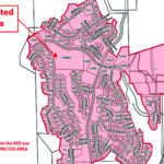
Cokato – a 20 person Forestry Unit Crew arrived from Cranbrook and spent Friday afternoon/evening sandbagging four homes in the Cokato Road area experiencing high water. Six homes on Thompson Road have been evacuated. The rest of the Cokato Road area remains on an evacuation alert.
 West Fernie – waters from Mutz Creek and a culvert flooded in between the West Fernie Dike and a secondary dike near Commons Street causing some flooding in nearby homes. After consultation with the dike engineer, it was determined that breaching the West Fernie Dike to allow the trapped floodwaters to drain was not recommended due to the long term risk it posed to the stability of the Dike. Pumps to pump the water over the dike are in place this morning. Residents of the area started digging into the dike Friday evening, creating a breach. That breach will be filled to maintain the integrity of the dike.

Kimberley – Mark Creek levels dropped again overnight; however, Kimberley Creek rose. There are two homes impacted by floodwaters and members of the fire department assisted with sandbagging. Crews are monitoring water levels on Kimberley Creek.
Wasa – water levels in the Kootenay River rose dramatically in the past 24 hours, creating flooding of low-lying areas and across Highway 93/95, which is currently closed. The RDEK will be monitoring water levels and sand and 2,000 sandbags have been delivered to the community hall for those residents who wish to sandbag.
Canal Flats – although there is localized flooding, including flooding at a local ranch, the situation in Canal Flats remains stable and no infrastructure is currently being affected.
 Dutch Creek – Dutch Creek was down approximately 20cm on Friday. The Evacuation Order for the HooDoo Resort Campground and surrounding residences remains in effect. Heavy equipment continues to move rock and add riprap reinforcement along the banks of Dutch Creek and work could be completed by late Saturday.
Fairmont Hot Springs – both Fairmont Creek and Cold Spring Creek remain within their channels and the situation in Fairmont has stabilized compared to earlier this week. Culverts are remaining clear and water levels have dropped in both creeks.
Invermere – some localized flooding reported in low-lying areas. Post Office in Invermere closed on Friday after heavy rainfall affected the roof.
Backcountry Roads – we are getting reports of several washouts and slides across numerous backcountry roads along with some bridge washouts. Extreme caution is advised if using backcountry roads.
Water Levels – Water levels stabilized in the Elk River somewhat Friday afternoon, after the river reached its peak. Rainfall in the Upper Elk Valley did cause an increase in water levels in the early evening; however, levels stabilized again shortly after the rain stopped.
For more information:
Check out the Regional District of East Kootenay’s Facebook page…
In the Elk Valley, call 1-250-423-2055
Contact Information Officer Loree Duczek at 250-919-3489
Loree Duczek/RDEK