Home »
Battle continues on Island Pond fire
Wildfires continue to keep Southeast Fire Centre crews busy heading into the final day of July.
Three major fires are burning in the region, along with another fire of note.
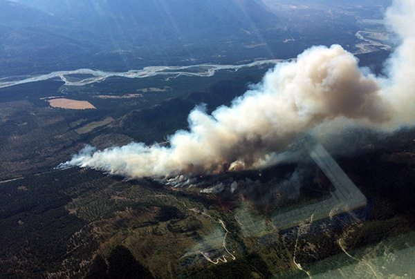
The one catching the most attention at this time, locally, is the Island Pond fire 12 km south of Canal Flats.
Started by a tree hitting a power pole on Sunday, July 30, the fire is now at an estimated 130 hectares and moving in a northeast direction; it is not contained at this time.
Two attack crews are on site and airtankers, helicopters and heavy equipment are being used to combat the fire.
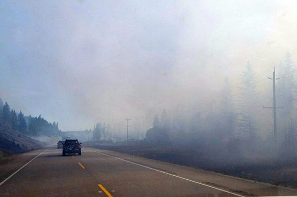
The fire caused closures of Highway 93/95 due to smoke but as of this morning (July 31), DriveBC is reporting the highway is reduced to single lane alternating traffic south of Green Road to north of Skookumchuck. Drive with caution and watch for traffic control and firefighting workers.
Power has been affected along parts of the highway corridor from de-energizing by BC Hydro crews to allow for firefighting operations.
Fire retardant has been placed around a cell phone tower in the path of the fire.
No other infrastructure is currently threatened, though there are rural properties in the area.
Another fire of concern is burning in the Middle Fork of the White River area. Discovered July 29, it is now at an estimated 280 ha and is located 40 km east of Fairmont Hot Springs.
The fire, which is moving into an old burn area from 2003, is not threatening any communities or infrastructure.
The fire is producing large amounts of smoke that might be visible in the region from Radium and Canal Flats and as far east as Alberta. It is not affecting air quality at this time but people with respiratory issues may wish to contact their health professionals.
Public access to the White-Middle Fork Forest Service Road in the Invermere Zone of the Southeast Fire Centre is now prohibited at the 45.5 kilometre point. The Lands Manager of the Rocky Mountain Natural Resource District has ordered the road closed due to concerns about public safety.
The Verdant Creek fire discovered on July 15, continues to burn in Kootenay National Park and Mount Assiniboine Provincial Park. The fire remains at about 4,833 ha according to the BC Wildfire Service.
As a result of cooler temperatures and moderate fire danger ratings, BC Parks – in consultation with the BC Wildfire Service – has reopened southern sections of Mount Assiniboine Provincial Park for public use, effective immediately.
The Sunshine Meadows area and the southern portion of the park are now open. However, the northern section that remains closed includes: the Simpson River drainage north of Og Lake Campground; the entire Surprise Creek drainage (north of Ferro Pass); and the entire Indian Creek drainage.
To manage the spread of the fire to the south in Kootenay National Park, Parks Canada hoped to conduct a burn out operation of an area on Mount Shanks July 30, if weather conditions and fire behaviour permit.
A burn out is a fire suppression operation where fire is set along the inside edge of a control line or natural barrier to consume unburned fuel between the line and the fire perimeter, thereby reinforcing the existing line and speeding up the control effort. This technique is only carried out if conditions permit. The safety of the public, our crews, park infrastructure and neighbouring lands is Parks Canada’s first priority.
It is not yet clear if the burnout was conducted.
Warmer temperatures will continue to produce increased fire activity along the remote southern boundary of the Verdant Creek fire. This activity, along with potential burn out operations will potentially produce a large smoke column that may be visible from the Bow and Columbia Valleys in the afternoons, and may settle into valley bottoms in the evening. This pattern is expected to continue for a few days.
Finally, a 39-ha fire in the Ward-Bloom area, south of Cranbrook, about four km from the US border, also continues to burn.
Lead image: An aerial view of the Island Pond fire from July 30. BCWS photo
e-KNOW