Home »

East Kootenay wildfire update
 Environment Canada’s thunderstorm watch has ended for the East Kootenay, with some damage inflicted in a few areas. Environment Canada’s Smoky Skies Bulletin remains in place, as several new lightning-caused fires are adding to it.
The following is a wildfire wrap-up for the East Kootenay for Sunday, August 12.
Meachen Creek – St. Mary Lake – Located at the north end of Kianuko Provincial Park, this 1,000-hectare fire is producing heavy smoke and residents of Kimberley and surrounding communities have been experiencing ash fall. The fire is about 46 km from Kimberley.
An evacuation ALERT was issued Saturday evening and remains in place.
The Meachen Creek Forest Service Road is now closed starting at the 16-kilometre mark at the junction of the Meachen Creek and White Boar forest service roads. In addition, BC Parks has also issued a partial closure of Kianuko Provincial Park.

Lost Dog Complex Fire – Evacuation ALERT remains in place for 121 address points in Ta Ta Creek area. There is no significant change to report from the last update. It remains estimated at 165.5 hectares (combined size of the four fires) and is burning approx. seven km northwest of Ta Ta Creek. The BC Wildfire Service (BCWS) had 26 firefighters, two helicopters, and six pieces of heavy equipment on the fire Saturday.
Coal Creek FSR – The Coal Creek Fire approximately 12 km east of Fernie is estimated at 713 hectares and is 0% contained. The wildfire has been displaying vigorous fire behaviour and is highly visible from Fernie and Alberta. This fire is not currently threatening communities. BCWS had five pieces of heavy equipment working on building containment lines and one helicopter on it today.
The Coal Creek Forest Service Road is closed beginning at the 33-km mark. The Leach Creek Forest Service Road is restricted beginning at the junction of Leach Creek Forest Service Road. The Corbin Road, and Morrissey Creek Forest Service Road are restricted beginning at the 0.3 km on Morrisey Forest Service Road, from the junction with Morrisey Road.
 Cross River Fire – Evacuation ORDER for nine properties on Settlers Road and Cross River FSR remains in place. The fire is estimated at 2,700 ha. The fire is burning in steep, difficult terrain. The Cross River Forest Service Road is closed starting at the 16 kilometre mark running to the Cross Mitchell River Forest Service Road and the Cross River Forest Service Road. This road closure applies to all non-industrial road traffic. Today there 17 firefighters, four pieces of heavy equipment and one helicopter on the fire.
Sage Creek – Burning 65 km southeast of Fernie along the BC/AB border, the Sage Creek Fire continues to burn in remote terrain. BCWS had 102 firefighters, eight helicopters, three pieces of heavy equipment and two airtankers on it today. Crews are working to reinforce the Flathead Sage Forest Service Road as a guard on the north end of the fire. The south side of the fire is burning upslope and connecting with the fuel break created from the Kenow Mountain wildfire from 2017. Crews and equipment continued to build guard on the east and west sides of fire along perimeter.
Bucketing and airtanker drops continued in priority areas.Heavy equipment will continue constructing dozer lines. Crews will provide support with pump and hose; sprinkler line to be set up on east flank. Aerial suppression will continue to limit further spread along the north perimeter.
The Flathead Sage Creek Forest Service Road is closed starting at the 81-kilometre mark at the junction of Flathead Kishinena Forest Service Road and the Flathead Sage Forest Service Road. No access is permitted on this section of road. This road will remain closed until the public is otherwise notified.
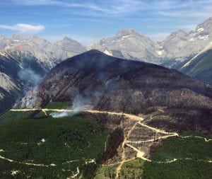 Whitetail Creek – 40-km north of Radium – estimated at 282 hectares, this fire is about 50% guarded and 35% contained. It does not pose a threat to local communities at this time. Effective immediately, the Beaverfoot Forest Service Road is closed beyond the 47-kilometre mark (near the Symond Creek Bridge). No access is permitted on this section of road. This road will remain closed until the public is otherwise notified.
Bull River/Quinn Range – There are two fires up the Bull. One is estimated to be approximately 170 ha and is near the 90-km mark. A second smaller fire is also burning near the 70-km mark.
Bloom Creek/Larch Creek – West of Newgate are two new small fires on the BCWS map today (0.6 and 2.1 ha) along with a 450 ha fire in nearby Larch Creek. All three are suspected to be caused by lightning.
Copper Mountain – Another new start is the Copper Mountain fire right on the Canada / US border approximately 14 km southeast of Yahk; it is suspected to be lightning caused and is estimated at 421 ha.
Akenside Creek Fire – Approximately 18 km west of Edgewater, this is a modified response fire and it is currently estimated at 450 ha.
Hog Ranch Fire – Near Parson this lightning-caused fire discovered July 20 is now 44 ha.
Other new fires
- There are two new lightning-caused fires in the high country south of Stoddart Creek, five and six km northeast of the Invermere crossroads. The Stoddart Creek fire is estimated at .02 ha and the Shuswap Creek fire is .01 ha.
- On August 11 a lighting-caused fire was reported at Weigert Creek, about 10 km south of Elkford. It is estimated at .01 ha in scale.
- Last night lighting caused a now .2 ha fire on Mount Erickson, about 12 km southeast of Sparwood.
- Also last night, lightning ignited a fire in Lynch Creek, about 16 km east of Hosmer. The fire is estimated at 10 ha by BCWS.
- On August 11, lightning ignited three fires in the high country north and east of Elko. One is two km south of Lost Lake Pass and it is estimated at 2.1 ha. There is another about 2.5 km northeast of that one (Elk Valley) that is .01 ha. And there is another .01 ha fire in the Lizard Range.
- Lightning also ignited a .01 ha fire one the east side of the Kootenay River in the Beaverfoot, eight km north of the Whitetail fire.
We all need to be vigilant out there. It is so dry and I’m urging everyone to use extreme caution. Be safe!
If you see a fire or burning violation, call 1-800-663-5555 or *5555 on a cellphone. The campfire, fireworks and open burning bans remain in place. Visit HERE for details on all bans.
The BEST resource for up-to-date information on the fire situation is the BC Wildfire Service – www.bcwildfire.ca
RDEK
