Home »
Fire activity increasing in Southeast Fire Centre
Fire activity in the Southeast Fire Centre has significantly increased over the past couple of days.
Since Wednesday, July 15 over 2,400 lightning strikes have been recorded in the region, resulting 38 new wildfires. As we re-enter a period of hot, dry, and windy weather, more new starts are anticipated, BC Wildfire Service (BCWS) reported.
Ground crews, aviation resources, and heavy equipment are continuing to work on clusters of fires throughout the Southeast Fire Centre. Current and emerging fires are assessed and responded to, starting with fires that are in or have the potential to impact the wildland urban interface or critical infrastructure, BCWS said.
There was an increase in wildfire smoke over many areas of the fire centre yesterday and today.
Much of this smoke is originating from fires south of the Canada-U.S. border in Washington and Oregon. Depending on wind, this smoke will be visible over the coming days.
There is a Smoke Forecast tool on the BC Wildfire Map/App that shows approximately where the smoke is coming from and what it will be like over the next two days.
For more information on wildfire smoke impacts and how you can protect yourself, visit the BC Centre for Disease Control.
For anyone recreating in the backcountry, BCWS recommends checking the DriveBC website for road closures and the BC Wildfire Map/App for wildfires in the area and possible area restrictions.
Please stay alert to changing conditions and emerging incidents, and ensure you have exit routes planned and a method of communication.
For those recreating on water, please remember that our aerial resources need plenty of space to safely and quickly collect water from rivers and lakes to help fight fires.
If firefighting aircraft are nearby, clear the area and stay near the shore to avoid interfering with firefighting operations. Interference with firefighting operations is not only dangerous, it also violates the Wildfire Act.
For everyone’s safety, please stay clear of active operations, follow all posted signs and directions from emergency personnel, and give crews the space they need to work to protect public safety.
East Kootenay fire situation
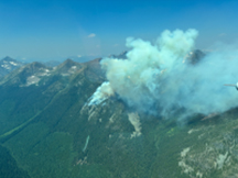
There are currently five out-of-control fires in the East Kootenay – with four clustered west of Kimberley in Meachen and Matthew Creek areas and another west of Dewar Creek in Calamity Creek, northwest of Kimberley. All five are lightning caused.
The Calamity Creek fire is an estimated 70 hectares (ha).
Fire Number N11020, in Matthew Creek is 567 ha and Fire Number N11027 (Bootleg Mountain) is 10 ha.
Fire Number N10982 (Tower Creek #3) is .01 ha and nearby and Fire Number N10947 (Tower Creek #2) is about 150 ha.
BCWS reports a helicopter is assigned to the cluster of fires in this area and response varies based on objectives.
There are no structures or infrastructure currently threatened by these fires.
Report a wildfire
The Southeast Fire Centre would like to thank the public for its continuing help in preventing wildfires.
You can report a wildfire, unattended campfire, or open burning violation by:
Dialing *5555 on a cell phone;
Calling 1 800 663-5555 toll-free;
Reporting through the BC Wildfire App Report a fire function;
Reporting through the app lets you upload images and can be used without service.
BC Wildfire Service file photo
e-KNOW