Home »

Increased wildfire activity expected for southeast
As forecast, thunderstorms passed through the Southeast Fire Centre yesterday, August 11. The BC Wildfire Service (BCWS) is currently responding to 10 new lightning-caused wildfires in the southeast, though no new fires were reported in the East Kootenay.
Thunderstorms are anticipated to continue today, with increased winds forecast for Saturday. “We expect to discover new fires from this weather pattern in the coming days,” BC Wildfire Service stated.
“Ground crews and aviation resources are being strategically deployed to new incidents in a priority sequence as they are discovered. As of this morning, these newly discovered fires have been initial attack targets; meaning they are able to be attacked directly. On most of these new fires, control lines are established adjacent to the fire. Direct attack is conducted on low-intensity wildfires that pose minimal risk to safety of firefighters.”
None of these new fire starts are currently threatening structures or infrastructure. As this is an evolving situation, BCWS will continue to update the information over the next few days as needed and as detection continues.
Currently, 24 fires are burning in the Southeast Fire Centre. Since April 1, 2022, there have been 112 fires covering 4,051 hectares. Of the fires this year, 77 per cent are lightning caused.
Nine fires are burning in the East Kootenay, including three wildfires of note, four out-of-control fires and two fires under control.
Cummings Creek wildfire, five km west of Sparwood, is today an estimated 52.6 hectares.
“Over the past several days, fire activity has continued within the perimeter and some growth has been observed on the southwest flank,” BCWS reported today.
“The fire has been backing into the wetter areas around the Cummings Creek and growth in the north and easterly directions has slowed, which has allowed the opportunity for crews to safely work on building limited access/egress routes.”
The Connell Ridge wildfire, 23 km south of Cranbrook is now an estimated 1,503.5 ha.
“The on-site conditions yesterday were not favourable for the larger planned ignition operation on the Connell Ridge wildfire. In the evening, conditions improved in the area, however by that point there was not adequate time left in the day to allow us to initiate the larger ignition area.
The ignition specialist was able to direct some smaller ignitions closer to the fire perimeter to clean up the edges where we had the ability to complete the mission prior to grounding aircraft for the night. The smaller ignition area was approximately 15 hectares in size,” BCWS outlined.
Increased fire behaviour has been observed with the recent warmer temperatures and nearby communities can continue to expect smoke to be visible, it added.
Crews and heavy equipment operators are continuing to construct additional guard lines around the perimeter to be prepared should the fire cross the completed containment lines.
“Crews will be conducting smaller ignition operations along the southern perimeter of the fire if conditions allow in order to bring fire to the control lines. These ignitions will likely occur in several smaller areas and may be up to 200 hectares in total,” BCWS said.
“Operations staff are developing plan of action which will involve laying out and building containment lines in operable areas that are closer to the fire’s edge on the north and south flanks and conducting some planned ignitions. If we receive favourable conditions, these operations will be supported with bucketing and ground crews and could occur early next week.”
An Evacuation Alert has been issued by the Regional District of East Kootenay in the vicinity of this fire. More information is available online: Click Here.
An Area Restriction is in effect for this incident in order to protect the public in areas where ongoing fire suppression activities are taking place. Full information including a map of the affected area is available: Click Here
Watch an overview of the Connell Ridge wildfire.
The third fire of note is at Weasel Creek along the B.C./Montana border, 39 kilometres southeast of Baynes Lake.
The fire is now about 1,087 hectares, in Canada.
“We are expecting to see aggressive fire behaviour in the coming days and into the weekend as the temperatures remain high. Expected fire growth is primarily towards the east and northeast,” BCWS reported today.
An Area Restriction has been expanded for this incident in order to protect the public in areas where ongoing aggressive fire behaviour is occurring. This Area Restriction reflects the continued need to protect the public due to extremely aggressive fire behaviour that will persist into the weekend and in areas where ongoing fire operations are taking place. We are anticipating significant growth on the northeast flank of this fire over the coming days. Full information including a map of the affected area is available: Click Here.

Among the four fires listed as out-of-control in the region is the Mount Evans wildfire, located approximately 29 kilometres southwest of Kimberley. It is currently estimated to be 33.5 hectares in size and is not threatening structures or infrastructure at this time.
“Upon detection, August 8, BC Wildfire Service personnel completed a reconnaissance flight and have developed a detailed response plan for this incident. During aerial reconnaissance planning, response officers noted that while the fire is burning in steep terrain at high elevation that is unsafe for ground crews to work on directly, it is surrounded by natural fuel breaks, a cliff face and a scree slope, it is also blocked by a burn scar from a previous fire,” BCWS said.
“While the ground is unsafe for crews to be actioning at this time, residents in the town of Kimberley and surrounding areas may notice aviation resources in the area for the duration of this fire as response officers will continue to monitor the fire from helicopters and airtankers may also be reinforcing natural fuel breaks with retardant as requested.”
The largest fire remaining out-of-control is at Stair Lakes (44 ha) in St. Mary’s Alpine Provincial Park.
The Mount Docking wildfire, 29 km northeast of Radium Hot Springs, is 36 ha.
Finally, the Gilnockie Provincial Park fire remains at two ha.
The fire danger rating in the Southeast Fire Centre today is a mix of moderate and high with small pockets of extreme and a section of low in the north of the Columbia zone.
BCWS reminds that campfires, Category 2 and Category 3 open fires remain prohibited.
“We would like to remind everyone to be responsible with any activity that could potentially create a wildfire. Human-caused wildfires are fully preventable and unnecessarily divert firefighting resources from naturally occurring wildfires.”
To report a wildfire call 1 800 663-5555 toll-free or *5555 on a cell phone. For the latest information on current wildfire activity, burning restrictions, road closures and air-quality advisories, visit: https://www.bcwildfire.ca
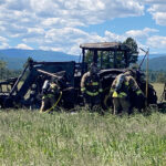
Lead image: Structure protection teams in Sparwood conducting practice drills to test for efficiencies. BCWS photos
e-KNOW