Home »
Status quo for regional fires of note
The BC Wildfire Service (BCWS) continues action on the three wildfires of note in the region, with little change reported today.
The Cummings Creek wildfire, five km west of Sparwood, is continuing to burn in extremely steep, inoperable terrain where it is unsafe for crews or equipment to work on suppression operations. The fire is now an estimated 52.6 hectares.
Two 21-person Unit Crews will be working on building access routes and contingency lines where safe to do so.
“BC Wildfire Service operations staff are observing the fire daily for ongoing data gathering and the Structure Protection Specialist has been working closely with the local fire departments and the regional district to assess response efforts for the best chance of success,” BCWS stated.
“Residents of Sparwood may be seeing influx of fire apparatus, structure protection unit trailers and personnel today. Most of these individuals will be structure protection personnel that will be triaging and assessing properties in the Sparwood area. This work is being done in a proactive manner to establish adequate positioning if required. Currently the community of Sparwood is not imminently threatened, however we want to give our structure protection personnel ample amount of time to deploy structure protection apparatus in the event of the fire progressing closer to the community of Sparwood.”
The Connell Ridge wildfire, 23 km south of Cranbrook, is still reported as 1,350 ha.
“A larger aerial ignition operation could occur today if conditions allow. Operations staff have spent the last several days building a comprehensive plan that outlines the conditions that will provide a window of opportunity to initiate the planned ignition. As much advanced warning as possible will be provided to the surrounding communities, as there will be an increase in smoke visible,” BCWS stated.
Crews and heavy equipment operators are continuing contingency guard construction over the coming days.
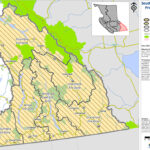
An Evacuation Alert has been issued by the Regional District of East Kootenay in the vicinity of this fire. More information is available online: Click Here
An Area Restriction is in effect for this incident in order to protect the public in areas where ongoing fire suppression activities are taking place. Full information including a map of the affected area is available: Click Here
And the Weasel Creek fire, 39 km southeast of Baynes Lake is 1,087 ha on the Canadian side of the border.
“The fire crossed the Canada–United States border on the afternoon of August 4, and is currently burning into the Flathead Valley, two kilometres west of Frozen Lake and 39 kilometres southeast of Baynes Lake. The fire was initially discovered in the United States on July 30,” BCWS said.
“We are expecting to see aggressive fire behaviour in the coming days and into the weekend as the temperatures increases. Expected fire growth is primarily towards the east and northeast.
An Area Restriction is in effect for this incident in order to protect the public in areas where ongoing aggressive fire behaviour is occurring. As the forecasted warm, dry weather occurs throughout this week, increased fire behaviour and growth will occur on this fire.”
BCWS today reports no new fires in the East Kootenay, with four fires still burning out-of-control: Mount Evans (33.5 ha) southwest of St. Mary Lake; Gilnockie Provincial Park (two ha); Stair Lakes (44 ha) at St. Mary’s Alpine Provincial Park; and Mount Docking (36 ha) northeast of Radium Hot Springs.
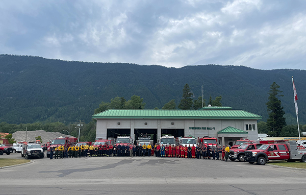
Lead image: CWS structure protection personnel and structure protection crews in Sparwood on August 10. BCWS photo
e-KNOW