Home »

Status quo with Sage and Whitetail wildfires
The BC Wildfire Service (BCWS) active wildfires website shows that only one new fire has been reported in the past 24 hours in the East Kootenay.
It is .01 hectare person-caused fire just east of Kallyn Road off Highway 95A in Meadowbrook, east of Kimberley, which was reported Sunday, August 5.
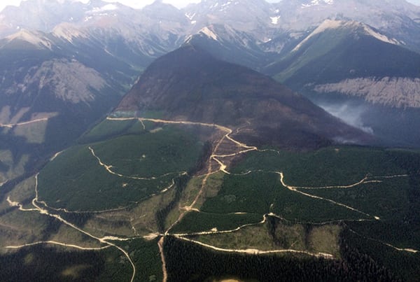
The BCWS continues to manage two wildfires of note, the Sage Creek wildfire 65 km south of Fernie (pictured above), now at 1,239 ha in scale and the 240 ha Whitetail Creek wildfire, about 17 km northeast of Spillimacheen, which was discovered July 27.
BCWS reports the Sage Creek wildfire “is a modified response fire, meaning it is managed using a combination of suppression techniques, including direct and indirect attack, and monitoring to steer, contain and otherwise manage fire activity within pre-determined perimeters. This type of response is used to minimizes costs and/or damage and to maximize benefits from the fire.”

This fire is burning in remote terrain. Crews are working to reinforce the Flathead Sage Forest Service Road as a guard on the north end of the fire. The south side of the fire is burning upslope and connecting with the fuel break created from the Kenow Mountain wildfire from 2017.
An Alberta Incident Management Team (IMT) is on site of this fire.
The Flathead Sage Creek Forest Service Road remains closed, starting at the 81- kilometre mark at the junction of Flathead Kishinena Forest Service Road and the Flathead Sage Forest Service Road. No access is permitted on this section of road. This road will remain closed until the public is otherwise notified.
Forty-one firefighters, three helicopters, three pieces of heavy equipment and two airtankers are engaged today (August 6) on the fire.
The cause of the fire remains under investigation.
This fire is producing a large column of smoke that is highly visible from Pincher Creek in Alberta and surrounding areas.
Crews are planning for future burn off operations. Expect to see additional smoke from this fire in the coming days.
Heavy equipment will continue constructing dozer lines. Crews will provide support with pump and hose. Aerial suppression will continue to limit further spread along the perimeter, BCWS related.
Classified as out of control, the Whitetail Creek wildfire is now 40% guarded and still 25% contained, BCWS reports.
This fire does not currently pose a risk to visitors of Kootenay National Park or to the Village of Radium Hot Springs, 40 km south.
However, as a precautionary measure, area closures and smoke advisories have been put into place by Parks Canada.
The Beaverfoot Forest Service Road remains closed beyond the 47-kilometre mark (near the Symond Creek Bridge). No access is permitted on this section of road. This road will remain closed until the public is otherwise notified.
Today there are 69 firefighters, six helicopters and 10 pieces of heavy equipment battling the fire.
Check BCWS’s active wildfires website for updates on wildfire activity.
e-KNOW