Home »

Stormy start to winter: AccuWeather
Winter and snow sports enthusiasts gear up! And folks putting off changing to winter tires, get ‘er done!
Weather prediction service AccuWeather says the rainy and cooler-than-usual autumn experienced by folks in the Rockies and Purcells will lead to a stormy start to winter.
 A stormy pattern typical of winter will set up over British Columbia and the Canadian Rockies, delivering rounds of rain and mountain snow across the region.
“Heavy snow will quickly pile up in the mountains, which should get the western ski season off to a good start,” AccuWeather Senior Meteorologist Brett Anderson said.
This will allow ski resorts in British Columbia and Alberta to establish a solid base early in the season that will last through the spring, he suggested.
While winter may start off wet and snowy across the region, a change in the weather pattern will cause the frequency of storms to decrease heading into February and March, AccuWeather said.
This flip in the weather pattern will also bring the potential for some brief shots of arctic air all the way down to the Lower Mainland of British Columbia, according to Anderson. These intrusions of arctic air may even reach areas closer to the coast, possibly making it all the way to Vancouver.
That should have folks in the vastly chillier prairies chuckling and stating “I wish.”
The prairies have already had a taste of winter with both chilly air and accumulating snow, but the worst of the season will hold off until the arrival of 2017, AccuWeather predicts.
The start of the season will feature occasional intrusions of chilly air, but the overall pattern will favor windier and milder conditions in cities such as Calgary and Edmonton.
“A pattern change by midwinter will likely send waves of very cold Arctic air directed into the southern Prairies for January and February,” Anderson said.
The onset of each wave of arctic air may bring some periods of snow, especially in southwestern Alberta, but this will be followed up by drier conditions once the frigid air takes hold.
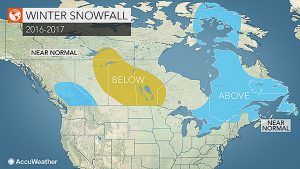
“Despite the arctic fronts, a persistent northwesterly flow of air during the second half of winter will suppress moisture far to the south, leading to below-normal snowfall over the eastern Prairies,” he said.
Meanwhile, the overall weather pattern this winter will favor warmer-than-normal conditions across far northern Canada, including Nunavut, the Yukon Territory and the Northwest Territories.
e-KNOW


