Home »

White-Middle Fork FSR closed due to new wildfire
Public access to the White-Middle Fork Forest Service Road in the Invermere fire zone is now closed at the 45.5-kilometre mark.
The road has been closed to protect public safety. BC Wildfire Service personnel are currently fighting a wildfire near the Middle Fork of the White River, about 40 kilometres east of Fairmont Hot Springs and 24 km northeast of Whiteswan Provincial Park. The fire, which has grown from 70-hectares to 280 ha overnight, is not threatening any communities or infrastructure at this time, but is producing large amounts of smoke.
The closure will remain in effect until further notice.
The fire, discovered July 29, is moving into an old burn area from 2003 and is not threatening any communities or infrastructure. The fire is producing large amounts of smoke that might be visible in the region from Radium Hot Springs and Canal Flats and as far east as Alberta. It is not affecting air quality at this time but people with respiratory issues may wish to contact their health professionals, BC Wildfire Service reported.
There are also two other smaller wildfires burning nearby. One (.8 ha in size) is at Dry Creek, about 12 km east of Fairmont, and the other is at Barr Creek (2.9 ha), about 16 km south of the Middle Fork fire.
The Ward-Bloom fire discovered on July 25 remains active at 39 ha. The fire is south of Cranbrook, about four km from the US border.
Another new person-caused fire was discovered yesterday (July 29) off Highway 3/95, about four km south of Moyie Lake.
Finally, the Verdant Creek fire, discovered July 15, continues to burn in Kootenay National Park. It is now at about 4,833 ha.
With hot and dry conditions forecast through this coming week, the Southeast Fire Centre is urging the public to be vigilant both in their communities and in the backcountry. All open burning, including campfires, is currently prohibited.
To report a wildfire or open burning violation, call *5555 on a cellphone or 1 800 663-5555 toll-free. For the latest information on current wildfire activity, burning restrictions, road closures and air quality advisories, visit: www.bcwildfire.ca
The Southeast Fire Centre extends from the U.S. border in the south to the Mica Dam in the north and from the Okanagan Highlands and Monashee Mountains in the west to the B.C.-Alberta border in the east. The Southeast Fire Centre includes the Selkirk Natural Resource District and the Rocky Mountain Natural Resource District.
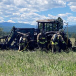
The above image is a stock photo from the BC Wildfire Service
e-KNOW