Home »
Why Cranbrook? The story beneath the map
By Stan Chung
Op-Ed Commentary
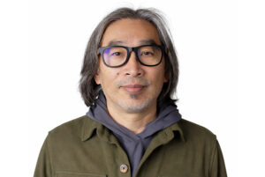 I have learned to love this land.
I love it because every year it reveals another layer I had never been taught to see.
One morning I was walking down Baker Street in Cranbrook before most of the shops had opened.
Store lights had come on, and a freight train announced itself, the sound rolling through downtown as it has for more than a century.
Nothing about the street asked to be noticed. It looked like what it often seems to be: a practical little city at the foot of the Rockies, built by people who made lives through mining, forestry, ranching, railways, weather, and work.
That was the first map I inherited. It was useful, but it was incomplete.
Then Ktunaxa friends, teachers, and leaders slowly dismantled that map.
Gwen Phillips, Sophie Pierre, Christopher Horsethief, Jason Louie, Smokii Sumac, Kyle Shottanana, and others taught it differently—through stories, meetings, walks, arguments, humour, policy, ceremony, friendship, and time—but the lesson gathered in the same place.
It begins and ends with the land.
Over time, I came to suspect this wasn’t only Cranbrook’s story. It was Canada’s.
Across the country, we inherit maps that tell us where towns, highways, mines, and cities are. Much less often do they tell us why they are there, or what stories the land had already begun generating long before the rest of us arrived.
After that, Baker Street stopped being where the story started. It became the newest layer of a much older place.
Every question returned to the same source.
Why Cranbrook?
Why the broad grasslands that became Joseph’s Prairie, and later Cranbrook? Why gold? Why coal? Why rail? Why Trail? Why the Columbia? Why this valley?
The answer kept waiting beneath the question: the land.
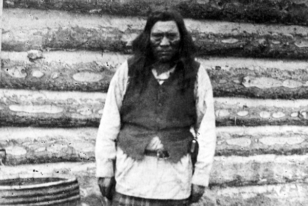
Chief Isadore (pictured) was the first person who forced me to see the place differently.
Sam Steele later called him “the most influential chief I have known,” a sentence that should have made Isadore one of the best-known people in the East Kootenay. Instead, many people know Steele while Isadore remains faint in public memory.
Sean MacPherson’s archival research explains why that absence matters: “In order for Cranbrook to exist, Chief Isadore had to be removed.”
Joseph’s Prairie is no longer empty land waiting for settlement once that sentence is understood.
It becomes ʔakisqakⱡiʔit, a Ktunaxa place of homes, horses, fields, creeks, law, memory, and political authority.
According to Ktunaxa accounts, Isadore’s family homes and implements were burned three separate times in an effort to force him and his family from the land.
Removing Isadore did not simply change a family. It cleared the political ground on which Cranbrook would later be built.
Suddenly words like settlement, development, and progress carry a different weight. They describe what was built, but also what was displaced.
I had thought I was redrawing the history of Cranbrook. Instead, the place kept getting older, wider, and more alive.
Drive about 250 kilometres east of Cranbrook and you reach Head-Smashed-In Buffalo Jump, one of Canada’s UNESCO World Heritage Sites.

For nearly 6,000 years, Indigenous peoples used wind, grass, stone, cliffs, ceremony, and collective knowledge to harvest buffalo and feed whole communities.
The Rockies stopped looking like barriers after that. They became routes Ktunaxa families crossed for generations, returning with meat, hides, horses, tools, and stories.
That was another layer: ecological, seasonal, ceremonial, older than Canada and far more sophisticated than the straight lines we later drew across it.
A small piece of obsidian changed the continent too. To most of us, it looks like black volcanic glass. To an archaeologist, it becomes evidence.
Scientists can trace its chemical fingerprint to Yellowstone, about 600 kilometres away, or to volcanic fields more than 1,000 kilometres north.
A blade that fits in the palm of your hand reveals trade, diplomacy, travel, and trust across western North America thousands of years before railways claimed to connect the country.
Then came gold.

In 1864, Wild Horse Creek drew miners from California, Oregon, Washington Territory, Idaho, Montana, the Fraser Canyon, and the Cariboo. Métis freighters hauled supplies. Chinese miners worked claims and opened businesses. Ktunaxa guides already knew the rivers and mountain passes.
Fisherville exploded to nearly 5,000 people, becoming one of the largest communities in what is now British Columbia.
Stand there today and the cottonwoods move in the wind. Birds replace the shouting. The creek sounds almost exactly as it did before thousands of miners arrived.
The land remains. People come and go.
The place kept widening.
Long before hydroelectric dams powered cities hundreds of kilometres away, these rivers already organized life, travel, salmon, trade, ceremony, and settlement.
Chinese merchants helped build Cranbrook’s commercial life, yet little on Baker Street remembers them.
Nearly 300 Ukrainian and other Eastern European coal miners were interned at Morrissey during the First World War. Their names were Kozak. Huculak. Ivanchuk. Wasylyniuk. Names that once marked them as “enemy aliens” now sound like neighbours, teachers, tradespeople, business owners, and Canadians.
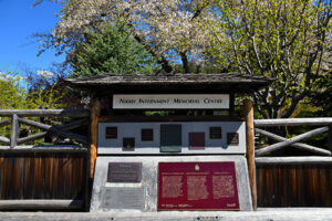
More than 22,000 Japanese Canadians were uprooted during the Second World War, with about 1,500 sent to New Denver.
Workers in Trail quietly produced heavy water for the Manhattan Project, the top-secret program that created the atomic bombs later dropped on Hiroshima and Nagasaki, killing more than 200,000 people by the end of 1945.
Above Field, fossils more than 508 million years old continue to draw scientists from around the world. Before these were mountains, they were the floor of a warm tropical sea.
At first, each story seems separate.
Indigenous law. Buffalo jumps. Obsidian routes. Gold rush camps. Chinese businesses. Internment. Atomic bombs. Fossils.
But each one belongs to the same place.
Political. Ecological. Ceremonial. Commercial. Wartime. Global. Geological.
And each one begins with the same question.
Why here?
The answer is never simply gold, coal, railways, forests, rivers, minerals, or opportunity.
The answer is the land: what it gives, what it withholds, what people take from it, what they fight over, what they try to own, what they poison, what they remember, and what they forget.
That is what my Ktunaxa teachers were trying to show me.
The land is not where history happened.
The land generates history.
It produces abundance and conflict, belonging and exclusion, prosperity and violence.
Governments rise because of it. Economies grow from it. People fight over it. Families protect it. Languages describe it.
Memory returns to it.
I still walk Baker Street. The lights come on. Freight trains still announce themselves before they appear. I stand differently now.
What changed was not the street. It was the map I carried.
Perhaps our maps need to be deeper and older and more complete.
This land. This land.
Glenbow Museum image
– Stan Chung, PhD, lives in Cranbrook, British Columbia. He is a writer, strategic advisor, speaker, and a 2026 Governor General’s Award laureate.