Home »
Elk Valley Trail (Trans Canada) update
By Robert Champagne
While most of us in the Elk Valley are moving through our days, little do we realize that deep in the woods all around us, much work is being done to construct the Trans Canada Trail, all the way from Round Prairie (just north of Elkford) to Elko.
What a great collaboration of the communities in the Elk Valley! Here are some of the highlights, broken down by sections.
Round Prairie to Elkford
 A 2.3-km re-route to bypass a very muddy and ATV-damaged section was completed by Cornerstone in July and is now a high quality cycling trail. Cabin Forestry is currently working on the remainder of the trail upgrades and re-routes on this trail.
One challenge will be to keep motorized users off the trails in Elkford. There have already been both ATVs and dirt bikes exploring the incomplete trail. This is currently being addressed through signage, community notifications, and word of mouth via the Elkford ATV club.
Elkford to Line Creek
 Land use agreement with Jemi is in place and Cabin Forestry will be doing the new construction on the Elkford South. Cornerstone will be constructing the Sulphur Springs Connector trail section. A geotechnical assessment of one steep side slope section revealed no terrain stability issues; just difficult trail construction.
A route that would utilize 3.5-km existing low use roadways and would require approximately 2.75 of easy new trail construction closer to the Elk River has been proposed. It would make for a very nice alternate to the Sulphur Springs main haul road. This trail will be started this fall by Cornerstone and hopefully completed before winter sets in.
Line Creek to Sparwood
 Cypress trail within the District of Sparwood is complete and the contractor, Elk Valley Excavations, is now working on the Whiskey Jack frontage trail.
Permission from Teck for the Wilson Corner / Lower Elk Valley Road section is now in place and Elk Valley Excavations is scheduled to work on this section very soon. The proposal to route the trail under Wilson Creek bridge was investigated and deemed too expensive because the trail would need to be located below the high water level.
Most of this section simply involves sign installation on roadways and existing trail. This will be done when the connecting trails are complete.
Sparwood to Hosmer

Work on the Coal Discovery Trail south from the Sparwood Campground is nearing completion, with 4.5-kms of trail upgrades, approximately 700 m of re-routes and 1.5-kms of new trail, which have been completed by Cabin Forestry. All they have left to do is a 250-metre re-route above the Sparwood Campground and a small amount of trail brushing.
Work is underway on the Coal Discovery Trail in the Ingham Creek area. Mow and Snow is working on a diverse mixture of new machine built trail construction, upgrades to existing trail, some new hand built trail, and bridge installation.

The owners of the deactivated road that connects the north end of Stephenson Road with the BC Hydro power line have agreed to have the trail run on their land. An agreement is in the works with the District of Sparwood and we hope to convert the deactivated road to trail this fall.
At this point it looks like the budget for the Sparwood portion of the Elk Valley Trail will be tight, so it is unlikely that significant work will be done of the portion of the CDT from Hosmer to the gravel quarry this year. District of Sparwood may be able to contribute to improvements here, but with a limited time window and limited contractor availability, there is uncertainty as to how much work is feasible this fall.
Hosmer to Fernie
 The route will follow the BC Hydro road from Hosmer to Porky Blue Creek as there is insufficient funding to do any new trail construction in this area this year.
Approximately 5.2-kms of the Coal Discovery Trail on Jemi Fibre property from Porky Blue Creek to the Ridgemont property line has been heavily impacted from logging that took place this summer. It is estimated that about 3.5-km of this trail will need to be rebuilt. Since logging did not take place in the creek gullies between cut blocks, only the regular upgrades (widening and smoothing) are required in these areas. DIG Trail Design is scheduled to work on this section starting in late September and going until the end of October. Mow and Snow is scheduled to complete trail upgrades and one re-route on approximately two kilometres of the Coal Discovery Trail north of Fernie when they are done in the Ingham area.
Fernie to Morrissey
 The new trail around the old Fernie Landfill and new section of the Montane trail was completed by Parastone Developments. Both are open to the public and are receiving heavy use by the public.
Drainage/ditching/culvert work on the existing Montane trail is currently underway by Parastone. The Roots to Branch H trail is complete and open to the public. There is a new hand painted sign proclaiming this trail as “Snoop Lion.” It is being used regularly as an access to the existing Southern Comfort trail.
Since Jemi Fibre does not want their River Road Extension haul road used for the trail, the only practical alternative is to leave the Branch H road at the one km mark and contour high above River Rd Extension. This will avoid crossing a steep area with a history of landslides. This makes for a section of new trail construction approximately five kms long. Work is in progress on this section by Backcountry Trail Experts, who have two crews working towards each other. Layout is still ongoing in the central sections.
Sarah Meunier from Trans Canada Trail is working with MoTI on plans for installation of signage on Cokato and Domin Roads.
Morrissey to Elko
 The plan to cross Morrissey Creek and utilize the Drinkwater Forest Service Road has been put on hold to allow time for the Fernie Trails Alliance to negotiate a land use agreement with the Nature Conservancy of Canada (NCC), which owns the property.
Permission has been granted from Trans Canada Pipelines to construct the Wigwam Hill trail realignment to bring the grades down from the current 25-30%. Trans Canada Pipelines has offered to coordinate and pay for up to two days of grading of the road through the Mount Broadwood Access Management Area from Elko to the Wigwam / Lodgepole gate.
Sarah Meunier from TCT has arranged for permission from BC Hydro to use the access road to Elko Dam for TCT and a license of occupation is now in place. The Fernie Trails Alliance is working with the NCC and the province to develop agreements to route the trail through the Mt Broadwood Access Management Area.
Ten kiosks are being constructed by Bisaro Woodworks and planning is underway for installation. Design work is underway for the kiosk information sign / map combinations.
All of the trail signage has been ordered via the Trans Canada Trail supplier and is expected to arrive before the end of September. It will be nice to get some signs up on the posts!
Happy trails!
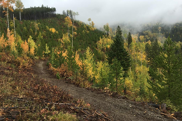
Lead image: Fall colours along Branch H of the trail at Cokato. Photos submitted