Home »
Area restriction amended for Matthew Creek area
The BC Wildfire Service continues to respond to the Matthew Creek wildfire (N11020) in the Matthew Creek area. This wildfire is estimated to be 1,826 hectares and is located approximately 10 km west of the City of Kimberley.
The recent downturn in weather has bolstered weeks of hard work by firefighters, heavy equipment, and aerial resources. As a result of these efforts combined with the more favourable weather conditions over the last few days, fire activity has been reduced.
To reflect changing conditions, the BC Wildfire Service is reducing the area restriction on the Matthew Creek wildfire effective today, September 3, at 1 p.m. (MT).
While the area restriction is being reduced in size, the need to protect public in areas of this wildfire continues. This restriction will remain in place until October 31, or until otherwise rescinded.
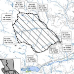
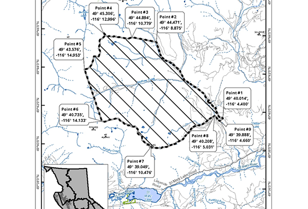
This Order applies to Crown land within the geographic boundaries described below and as outlined on the above map:
Commencing approximately 4.7 km up Matthew Creek FSR where Mark Creek FSR branches off at Point #1 (49° 40.014′, -116° 4.400′);
Keep left to follow Matthew Creek FSR for approximately 10.9 km to where Matthew Creek FSR ends at Point #2 (49° 44.471′, -116° 8.875′);
Head west on a bearing of 289 degrees for 2.4 km to the unnamed peak at Point #3 (49° 44.894′, -116° 10.779′);
Follow the ridgeline west to the unnamed peak at Point #4 (49° 45.306′, -116° 12.996′);
Follow the ridgeline southwest to the unnamed peak at Point #5 (49° 43.576′, -116° 14.953′);
Head South on a bearing of 169 degrees for 5.4 km to the peak at Point #6 (49° 40.735′, -116° 14.133′);
Follow the ridgeline Southeast to the peak of Bootleg Mountain Point #7 (49° 39.049′, -116° 10.476′);
From Bootleg Mountain, follow the drainage East along the north boundary of the Bootleg Mountain Recreation Site to the confluence of the unnamed creek and Matthew Creek at Point #8 (49° 40.208′, -116° 5.031′);
Follow Matthew Creek South to a point below the point of commencement at Point #9 (49° 39.888′, -116° 4.660′);
Take a bearing of 53 degrees for 0.4km to the Northeast to return to the point of commencement.
Note: Travel is NOT permitted on the Matthew Creek FSR.
Under this Order and section 11(2) of the Wildfire Act, a person must not remain in or enter the restricted area without the prior written authorization of an official designated for the purposes of the Wildfire Act, unless the person enters the area only in the course of:
Travelling to or from his or her principal residence, that is not under an evacuation order;
Using a highway as defined in the Transportation Act;
Travelling as a person acting in an official capacity as defined in s.56 of the Wildfire Act;
Travelling for the purpose of supporting wildfire suppression or enforcement patrol activities.
Failure to comply with Section 11 restricted area requirements may result in a violation ticket for $1,150.
BC Wildfire Service