Home »
Bill Nye wildfire continues to grow
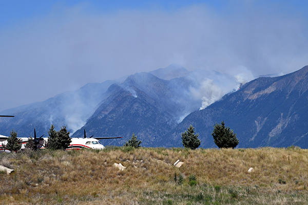
The Bill Nye Mountain wildfire seven km southeast of Wasa continues to rapidly grow, now being estimated by the BC Wildfire Service as 784 hectares in size.
“An increase in winds is resulting in increased visibility and smoke that is visible from Wasa, Cranbrook, Kimberley and surrounding areas,” BC Wildfire Service reports today (July 18).
 An evacuation alert is in place for 54 properties in the Lazy Lake, Lakit Lake, Holmes Road, and Wildhorse FSR areas.
Heavy equipment is on scene today to start work building a machine guard on the west flank at the base of the mountain. A helicopter is also involved in the fight.
The lightning-caused Tanglefoot Creek wildfire, discovered July 16 about 15 km southeast of the Bill Nye fire, remains out-of-control at 195 ha.
The Big Lake fire eight km south of Wasa is still being held at 11 ha.
The lightning-caused Ptarmigan Creek wildfire five km north of Whiteswan Lake Provincial Park has jumped in size from .6 ha to 10 ha in 24 hours and is out of control.
A new fire was reported yesterday in Drinkwater Creek, about 5.5 km south of Morrissey. Lightning-caused, the fire is out-of-control at .01 ha.
The lightning-caused fire in Dewar Creek, discovered July 16 about 2.5 km west of Price Lake in St. Mary Alpine Provincial Park, about 36 km northwest of Kimberley, is out-of-control at 42 ha.
The remaining wildfires in the region are either being held or under control.
A fire discovered July 16 in Flathead Pass, between the Taylor and Flathead Ranges, about two km from the border with Alberta and Castle Provincial Park is under control at .1 ha. It is about 30 km southeast of Fernie.
A lightning-caused fire on Maguire Mountain, about 9.5 km northeast of Grasmere, is under control at 1.1 ha.
The lightning-caused fire on Gold Mountain, southwest of Wardner, discovered July 9, is still under control at 1.31 ha.
Discovered July 2, the Moyie River/Lumberton fire is still under control at 29 ha.
The Granite Creek fire in the Purcell Wilderness Conservancy continues to be held at 26 ha.
The Bear Creek wildfire, discovered July 2 on the west side of the Kootenay River Valley, east of Invermere, is under control at 1.5 ha.
Four fires north and northeast of Creston also continue to cause headaches for BC Wildfire Service.
The Cultus Creek fire, on the west side of Kootenay Lake, about 30 km northwest of Creston, remains out-of-control at 611 ha.
The Kamma Creek fire discovered July 10 about 30 km northeast of Wynndel, remain out-of-control at 140 ha.
The lightning-caused Akokli Creek wildfire is now a fire of note, out-of-control at 356 ha, about five km east of Boswell.
This fire is highly visible from Boswell, Creston, and surrounding areas, as well as those travelling on Highway 3A.
“The fire continues to burn in steep and unworkable ground in the Akokli drainage. Officers continue to monitor the fire daily and are developing a contingency plan. Fire behaviour yesterday was low to moderate surface fire. Personnel are preparing to establish anchor points,” BC Wildfire Service reported today.
Finally, the Redding Creek wildfire, six km northeast of the Akokli Creek fire, remains out-of-control at 131 ha. The lightning-caused fire was discovered July 11.
Check out the BC Wildfire Service Wildfire Dashboard for updated information on the 306 wildfires currently burning in British Columbia.
Lead image: The Bill Nye Mountain wildfire, as seen from Canadian Rockies International Airport July 17, has exploded from .6 ha to nearly 800 ha in a matter of days. Ian Cobb/e-KNOW photo
e-KNOW