Home »

Flathead fire forces evacuation of Waterton
Update on regional wildfires
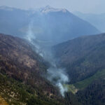
The Kenow Mountain wildfire has spread from the Flathead Valley into Waterton Lakes National Park in southwestern Alberta, forcing an evacuation order this afternoon (Sept. 8).
The lightning-caused fire on August 30 has grown to more than 7,800 hectares in size due to changes in weather conditions that have led to increased potential danger and hazards, causing the evacuation of the park, Parks Canada explained.
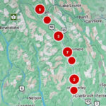
The Kenow is the largest of six wildfires currently burning in B.C.’s southeastern corner, according to the BC Wildfire Service (BCCS) active wildfires website.
About 10 km southwest of the Kenow fire, just north of the US border, is the 750 ha Elder Creek fire, started by lightning August 31.
About 25 km northwest of that fire is the Cabin Creek fire, now at 45 ha since being discovered Sept. 2. The fire is believed to have been started by lightning.
A further 24 km northwest of Cabin Creek is the Soowa Mountain fire, begun August 31 by lightning. The fire is now 909 ha.
About 14 km northeast of that fire is the Lodgepole FSR fire, another lightning-caused fire from August 31.
And about 12 km northeast of the Lodgepole is the 27 ha Centre Mountain fire, also begun by lightning on August 31.
The following is a video update on the fire situation courtesy Loree Duczek/RDEK
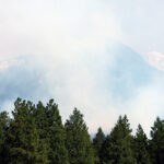
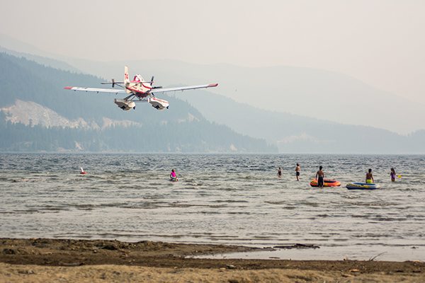
Five ‘fires of note’ continue to burn in the region, filling the skies with thick smoke.
The Linklater Creek fire (formerly Robinson Mountain) has now burned about 927 ha in B.C., 14 km southwest of Newgate.
The total fire size is estimated to be 8,563 ha, with the majority of this fire burning in Montana.
BCWS reports there are 16 firefighters, a helicopter and nine pieces of heavy equipment on the fire today. The BC Wildfire Service is constructing guard focusing on the northeast side of the fire.
“Helicopter bucketing will focus on hot spots. Low visibility will impact air operations today. Minimal growth has been experienced over the last several days on this fire,” BCWS noted.
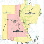
As a precautionary measure, in the interest of public safety, the Regional District of East Kootenay (RDEK) has implemented an Evacuation Order for some areas on the west side of Lake Koocanusa, and an Evacuation Alert for some areas on the east side of Lake Koocanusa, effective immediately, Sept.2.
For detailed information about this Evacuation Alert, people should call the Regional District of East Kootenay at 250-426-2188 or visit its website.
For additional information on this fire.
The Lamb Creek fire, begun August 28 by lightning, is now at an estimated 1,654 ha and not contained.
A total of 48 firefighters, three helicopters and 14 pieces of heavy equipment are on the fire today.
“Crews continue to work on building hand and machine guard around the fire, and may use controlled ignition to burn out fuels between guard lines and the fire, if conditions allow. Air tankers and helicopters may be used at any time to cool the fire, allowing ground crews and heavy equipment to continue construction and reinforcement of guard lines. Structural protection units have been placed in priority areas, and continue to assess values. The fire has been burning at low intensity for the last few days due to smoky conditions and calm winds, resulting in minimal growth. However, a change in weather starting later today will likely bring increased winds and clearer skies, resulting in the potential for increased fire activity,” BCWS reported.
An Incident Management Team has taken over operations of this fire, and additional crews continue to arrive daily.
The Regional District of East Kootenay issued Evacuation Orders for the Moyie Lake area.
Effective Aug. 30, there is a Forest Service Road closure for the Lamb Creek Forest Service Road starting at the 1.5 kilometre mark of the Mineral and Lamb Creek Forest Service Road to the Whitney and Irishman Creek Forest Service Road junction.
Effective Aug. 29, there is an area restriction in effect for Moyie Lake. This area restriction means that no watercraft are allowed on Moyie Lake at any time.
The St. Mary fire, 14 km northeast of Cranbrook in ?Aqam, is 76% contained, BCWS reported this morning.

“This fire is currently being held,” BCWS said.
As of today there are 15 firefighters and two pieces o heavy equipment on the fire.
Effective September 1, the RDEK issued an evacuation alert for the St. Mary River area where it meets the Kootenay River and the surrounding area. For more information on this alert call the RDEK at 250-426-2188 or visit www.rdek.bc.ca.
The White River Complex fire, 37 km northeast of Canal Flats, is still at an estimated 12,000 ha, BCWS reports.
“Increased fire behaviour resulted in removing crews and equipment, to ensure the safety of personnel. Personnel are continuing to work in priority areas where it is safe to do so. Structural protection units are in place in priority areas. Guard is being built in safe locations. The BC Wildfire Service personnel are closely monitoring this fire and creating contingency plans,” BCWS said.
This fire is the result of three wildfires coming together (White River, Grave Creek and North White River), with the White River fire starting July 29 due to lightning.

Effective Sept 3, the White Swan Lake area is under Evacuation Order. For more information on this order, people should call the Regional District of East Kootenay at 250-426-2188 or visit www.rdek.bc.ca.
To also aid in fire suppression activities and for public safety, there is a complete road closure on the White Rock Forest Service Road beginning at the 34-kilometre mark extending to the 73.3-kilometre mark and the White Swan Forest Service Road from the 10-kilometre mark until the 32-kilometre mark. Also; the White-Schoefield Forest Service Road starting at the 78 kilometre mark, the White River Forest Service Road starting at the 32 kilometre mark and the White-East Fork Forest Service Road starting at the 60 kilometre mark.
The fifth fire of note is also the longest burning. Now almost two months old (began July 15 by lightning), the Verdant Creek wildfire in Kootenay National Park and Mount Assiniboine Provincial Park is 17,644 ha.
“The majority of the recent growth in the remote southeastern area of the fire. Parks Canada continues to work with the BC Wildfire Service in managing this fire,” Parks Canada reported.
White-Moscow Creek fire: This person-caused fire on Sept. 1, about 18 km east of Fairmont Hot Springs, is now at 61.3 ha.
The Mount King George fire in Height of the Rockies Provincial Park, begun August 29 by lightning, has burned 203 ha. This fire is about 49 km east of Invermere.
Quinn Creek fire: Started by lightning on August 10, this fire east of Top of the World Provincial Park is now at 2,700 ha. No other information available.
White Creek fire: Started by lightning August 11. Located on the southern edge of St. Mary’s Alpine Provincial Park, about 42 km northwest of Kimberley, the fire is now at 322 ha.
For detailed updates on the regional wildfire situation check out the RDEK’s Facebook page.
e-KNOW