Home »

High streamflow advisory for East Kootenay
The B.C. River Forecast Centre (BCRFC) has issued a high streamflow advisory for the entire East Kootenay.
The advisory, which covers most of southern British Columbia, includes the Kootenay River and tributaries through the region.
A high streamflow advisory means that river levels are rising or expected to rise rapidly, but that no major flooding is expected. Minor flooding in low-lying areas is possible.
“A period of unsettled weather is occurring across southern British Columbia. Rainfall amounts in the five to 35 mm range have been observed throughout the region since yesterday. On Monday, an upper low is expected to track across southwest B.C., bringing wrap around precipitation with the potential for heavier rainfall and thundershowers to areas in the south interior and Kootenays,” the BCRFC stated.
“Responses in rivers is expected to be highly variable across southern B.C. in response to upcoming weather, with rising rivers expected in areas which receive the heaviest rain. Hydrologic modeling is indicating the potential for moderate flows, in the two-year to five-year range, in areas. Given the uncertainty in the exact locations and intensity of rainfall, it is possible that small and medium sized watersheds throughout the region may experience high flows on Monday and Tuesday.”
The public is advised to stay clear of the fast-flowing rivers and potentially unstable riverbanks during the high-streamflow period. Be prepared and know your hazards.
The River Forecast Centre continues to monitor the conditions and will provide updates as conditions warrant
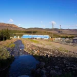
Lead image: The Kootenay River through Picture Valley July 1. Ian Cobb/e-KNOW photo
e-KNOW


