Home »

Second fire of note ablaze in region
There is now a second wildfire of note in the East Kootenay as the Weasel Creek fire has exploded to 880 hectares in just two days.
The fire is located in both the US and Canada, about 22 km east of Roosville, two kilometres west of Frozen Lake and 39 kilometres southeast of Baynes Lake.
The fire crossed the Canada–United States border on the afternoon of August 4, and is currently burning into the Flathead Valley, two kilometres west of Frozen. The suspected lightning-caused fire was initially discovered in the United States on July 30. Approximately 620 of the total 880 hectares is burning on the Canadian side of the border.
“The Incident Management Team assigned to the Connell wildfire, approximately 15 km south of Cranbrook, is collaboratively working with the assigned Incident Management Team from the United States on our respective side of the border to establish a response plan, BC Wildfire Service (BCWS) reported.
“The structure protection specialist assigned to the Connell Ridge wildfire is assessing the need for any structural protection resources around the Weasel Creek wildfire.

As for the Connell Ridge wildfire, discovered August 1, it is now an estimated 1,350 ha.
“There was approximately 200 ha of growth along the north and northeast flank of the fire yesterday (August 5),” BCWS noted. “Less aggressive fire behaviour was observed yesterday because of cooler temperatures. Fire behaviour is expected to increase as temperatures rise over the weekend. The fire is continuing to burn in high elevation and pockets of rank three was observed.
“The north and northeast section of the fire is burning in steep and inoperable terrain. Machine guard is being constructed from the southeast corner to the southwest corner to establish a containment line.
“Crews are working to determine the most suitable location for containment lines on the east flank and northwest. A Structure Protection Specialist is assessing potential values at risk and develop strategies for structure protection. An incident management team has taken over this incident.”
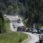
 An Evacuation Alert has been issued by the Regional District of East Kootenay in the vicinity of this fire.
And an Area Restriction is in effect for this incident in order to protect the public in areas where ongoing fire suppression activities are taking place.
BCWS reports that 61 firefighters, 32 pieces of heavy equipment and six helicopters are on the fire today, including three unit crews, two initial attack crews, one Structure Protection Specialist, three structure protection personnel, and an Incident Management Team and other operational and support staff supporting the response.
Meanwhile, the Cumming Creek wildfire five km northwest of Sparwood remains out-of-control at about 10.10 ha.
Discovered August 3, the fire is believe to be lightning-caused.
The Gilnockie Provincial Park fire, ignited by lightning on August 4, is still out-of-control at .44 ha. The fire is about 24 km east of Yahk.
The Stair Lakes fire, located in St. Mary’s Alpine Provincial Park about 28 km northwest of Kimberley, remains out of control at 64.8 ha. The suspected lightning-caused fire was discovered July 31.
Finally, the Mount Docking wildfire, about 28 km east of Radium Hot Springs, is still out of control at 13.4 ha. Discovered July 30, it is suspected lightning-caused the fire.
e-KNOW