Home »

White – Grave fires now wildfires of note
Aside from another new fire discovered yesterday in the Lewis Creek area, about 17 km west of Moyie Lake (at .2 hectares in size), BC Wildfire Service and Regional District of East Kootenay (RDEK) are reporting progress on several wildfire fronts.
The White River wildfire and the Grave Creek wildfire are now being referred to as the “White River complex wildfire,” because they are near the same forest service roads that currently have restrictions in place.
The fires are about 15 kilometres apart and have not experienced any significant growth in recent days. The White River wildfire covers about 1,214 hectares, while the Grave Creek wildfire covers about 980.2 hectares. The combined size of this complex is 2,194 hectares and are together designated as a Wildfire of Note on the BC Wildfire Service website.
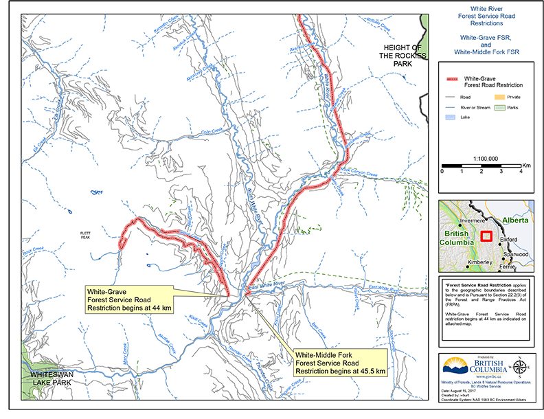
Forest Service Road Closure: to support fire suppression activities and protect public safety, there is a modified road closure (to non-industrial traffic only) on the White-Middle Fork Forest Service Road at the 45.5-kilometre mark as well as on the White-Grave Forest Service Road beginning at the 44-kilometre mark.
The Island Pond wildfire is in mop up, with 57 people and four pieces of heavy equipment working on it. It remains 100% contained and today is estimated at 1032.5 hectares.
The Lamb Creek/Tate Creek fire is now classified as under control and is 100% contained. It is still estimated at 25 hectares with 20 personnel, four pieces of heavy and one helicopter on it.
The Verdant Creek wildfire in Kootenay National Park and Mount Assiniboine Provincial Park are now estimated at 14,131 ha. The fire received 15mm of rain yesterday, which will help crews make progress.
A travel advisory remains in place on Highway 93 from Radium Hot Springs to Castle Junction due to Fire fighters will be working adjacent to the highway and reduced speed zones will be in place. Drivers should anticipate possible delays. Check www.drivebc.caor www.alberta511.ca
The Quinn Creek fire east of Top of the World Provincial Park is burning in a remote area and is not posing any threats to any communities. BCWS now has it at 70 ha in size.
The White Creek-Monitor fire (northwest of Kimberley) is still estimated at 30 ha burning in a high elevation remote area and not threatening any structures or communities. It is being closely monitored.
The Forster Creek fire west of Radium Hot Springs is out and the Fording River Fire (southeast of Elkford) is also out.
“Some places across the region got more rain than others in the past 24 hours and it looks like it will get hotter and drier over the next couple of days. A reminder that although that rain felt great and cooled things off, conditions are still extremely dry and as the temperatures get hotter toward the weekend, that drying trend will continue,” the RDEK reported.
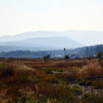
“The smoke in the region today is once again primarily coming from the huge fires in the Cariboo/Kamloops region and other fires to our west (the local fires are contributing some as well of course). With overnight inversions possible over the next couple of days, we could see variable and sometimes very smoky conditions. The Air Quality Advisory remains in effect.”
A reminder that the Off Road Vehicle prohibition remains in effect as does the campfire ban.
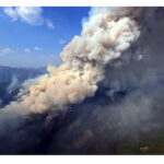
Lead image: A water bomber hits the fire at Lamb Creek last week. Linda Botterill photo
e-KNOW