Home »

New road closure for White River Complex wildfire
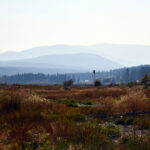
In the interest of public safety, the BC Wildfire Service (BCWS) is implementing an additional modified road closure (to non-industrial traffic only) near the White River Complex wildfire, which is burning about 47 kilometres northeast of Canal Flats.
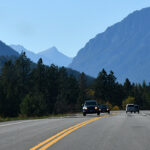
Effective immediately (Aug. 18,) this closure applies to the White River Forest Service Road starting at the 32-kilometre mark and the White-East Fork Forest Service Road starting at the 60-kilometre mark (near Munroe Lake). This means that no vehicles are permitted on these sections of road apart from industrial traffic.
With strong and gusty winds expected in the Southeast Fire Centre this afternoon, the BC Wildfire Service is implementing this additional road closure as a precautionary measure.
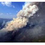
The White River Complex includes the White River wildfire (N21420) and the Grave Creek wildfire (N21628), which are about 15 kilometres apart. As of the afternoon of Aug. 18, the White River fire covered about 1,214 hectares and the Grave Creek fire covered about 980 hectares, for a total of about 2,194 hectares. These fires are being responded to together.
A new lightning-caused fire is also being reported by BCWS in the North White River, eight km west of the White River Complex. The fire is estimated at 1.1 ha.
There is also another new lightning-caused fire on Bingay Mountain (.1 ha), as km northwest of Elkford.
The Southeast Fire Centre extends from the U.S. border in the south to the Mica Dam in the north and from the Okanagan Highlands and Monashee Mountains in the west to the B.C.-Alberta border in the east. The Southeast Fire Centre includes the Selkirk Natural Resource District and the Rocky Mountain Natural Resource District.
To report a wildfire or open burning violation, call *5555 on a cellphone or 1 800 663-5555 toll-free. For the latest information on current wildfire activity, burning restrictions, road closures and air quality advisories, visit: www.bcwildfire.ca.
e-KNOW