Home »

Rainfall warning for Elk Valley
Environment Canada has this morning (Feb. 23) issued a Special Weather Statement in effect for Elk Valley, warning of significant rainfall and rising freezing levels.
There is also a Winter Storm Warning in effect for Highway 3 – Paulson Summit to Kootenay Pass.
From now through Monday morning, two moisture laden Pacific frontal systems are pushing into the B.C. interior through the remainder of the weekend. The first round of significant precipitation will taper off early this afternoon. The second round will give periods of heavy rain from this evening to early Monday morning, Environment Canada forecasted for the Elk Valley.
The highest precipitation totals are expected to be over southwestern sections including Fernie and Morrissey. By the end of the weekend, these locations could receive in excess of 50 mm of rain.
This rainfall in combination with rising freezing levels and a melting snowpack could create areas of pooling water, and other flood risks.
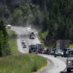
Hazardous winter conditions are expected along Highway 3 including Kootenay Pass from now through Monday morning.
Precipitation is expected to continue through early Monday morning as another system reaches the area today (Feb. 23). The snow levels are rising to near the elevation of Kootenay Pass by this afternoon. Wet snow or snow mixed with rain can be expected tonight with an additional 15 to 20 cm of snow accumulation possible at the pass.
Rapidly accumulating snow could make travel difficult over some locations. Visibility may be suddenly reduced at times in heavy snow.
e-KNOW file photo
e-KNOW