Home »

Area Restriction expanded for Bill Nye wildfire
The BC Wildfire Service (BCWS) has increased the area of the Area Restriction Order for the vicinity of the Bill Nye Mountain wildfire, which originated seven kilometres southeast of Wasa in the Cranbrook Fire Zone.
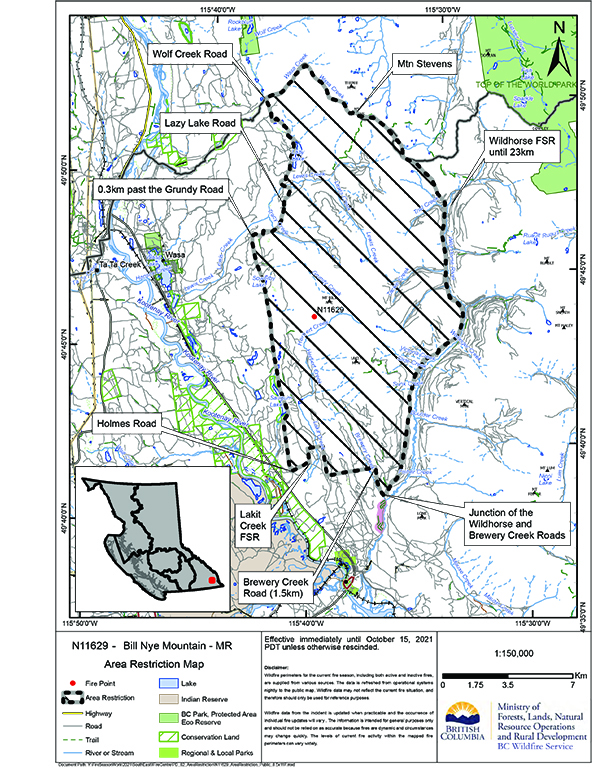
The increased area restriction reflects the continued need to protect the public in areas where ongoing fire suppression activities are taking place and to avoid interference with fire control. The fire is currently estimated at 2,990 hectares.
This order is currently in effect and will remain in effect until 12:00 noon (PDT) on October 15, 2021, or until rescinded. The order applies to Crown land within the geographic boundaries described below and outlined in the correlated map:
- Commencing at the junction of the Wildhorse and Brewery Creek road, northwest to junction of Holmes road.
- North to 0.3 km on the Grundy road.
- Following Lazy Lake road to junction of Wolf Creek road.
- Northeast following Wolf Creek then southeast following Wolf Creek to Mt Stevens continuing south to the Wildhorse FSR at 23 km mark.
- Following Wildhorse River back to point of commencement.
- Note: Travel on Wildhorse FSR is permitted.
- Access to Lazy Lake Recreation site is prohibited.
Under this Order and section 11(2) of the Wildfire Act, a person must not remain in or enter the restricted area, unless the person:
1) first receives written authorization of an official designated for the purposes of the Wildfire Act, or
2) enters the area only in the course of:
- travelling to or from his or her residence, that is not under an evacuation order;
- travelling to or from private or leased property for the purpose of accessing a secondary or recreational property, that is not under an evacuation order;
- using a highway as defined in the Transportation Act;
- travelling as a person acting in an official capacity as defined in s.56 of the Wildfire Act; or
- travelling for the purpose of supporting wildfire suppression or enforcement patrol activities.
BCWS today reported the Bill Nye Mountain area received 10 mm of rain and is expected to receive more today. This continued rain and rise in relative humidity has lowered fire behaviour and bolstered the hard work that crews have put in.
“Today scattered thundershowers continue in the southern part of the fire centre with a mix of sun and cloud in the north. Watch for localized heavy downpours. Overnight expect good relative humidity recoveries and generally light winds. Monday, fog and low cloud in the morning reducing visibility. Warming and drying trend starts Tuesday with temperatures increasing again as a ridge pushes in, temps reaching the high-20s to mid-30s by Wednesday or Thursday.
“Today, crews continue to action hot spots found by drone scan and mop up is ongoing on the northeast flank. With a considerable amount of rain taken in the area, the incredibly steep and wet terrain is being evaluated for where crews and resources can work safely in the new conditions. Nearly half of the fire perimeter has been wrapped with either machine guard, hand built fuel free or hoselay. Helicopter support is available today, but not anticipated,” BCWS said.
Road closures and area restrictions are subject to change depending on fire activity. For the most current information please visit the bans and restrictions section of the BC Wildfire website for the Southeast Fire Centre, or visit: https://ow.ly/ILP230rPS7h.
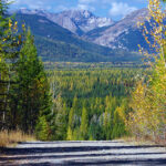
Lead image: The Bill Nye Mountain Wildfire as of August 8. BCWS photo
e-KNOW